You are here: Home > Network List > TA - USArray Transportable Network (new EarthScope stations) Stations List
> Station H31M Peel River, Yukon, CAN > Earthquake Result Viewer
H31M Peel River, Yukon, CAN - Earthquake Result Viewer
| Earthquake location: |
Central East Pacific Rise |
| Earthquake latitude/longitude: |
-9.0/-108.5 |
| Earthquake time(UTC): |
2018/06/24 (175) 18:43:42 GMT |
| Earthquake Depth: |
10 km |
| Earthquake Magnitude: |
5.7 Mww |
| Earthquake Catalog/Contributor: |
NEIC PDE/us |
|
| Network: |
TA USArray Transportable Network (new EarthScope stations) |
| Station: |
H31M Peel River, Yukon, CAN |
| Lat/Lon: |
65.81 N/134.34 W |
| Elevation: |
642 m |
|
| Distance: |
77.0 deg |
| Az: |
349.392 deg |
| Baz: |
153.82 deg |
| Ray Param: |
0.050595712 |
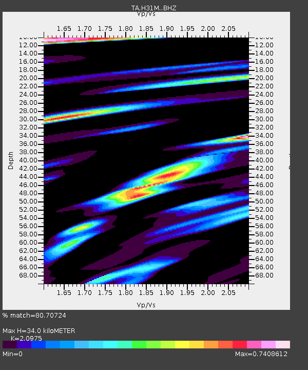
| Estimated Moho Depth: |
34.0 km |
| Estimated Crust Vp/Vs: |
2.10 |
| Assumed Crust Vp: |
6.419 km/s |
| Estimated Crust Vs: |
3.06 km/s |
| Estimated Crust Poisson's Ratio: |
0.35 |
|
| Radial Match: |
80.70724 % |
| Radial Bump: |
400 |
| Transverse Match: |
75.7294 % |
| Transverse Bump: |
400 |
| SOD ConfigId: |
13570011 |
| Insert Time: |
2019-04-30 11:16:44.240 +0000 |
| GWidth: |
2.5 |
| Max Bumps: |
400 |
| Tol: |
0.001 |
|
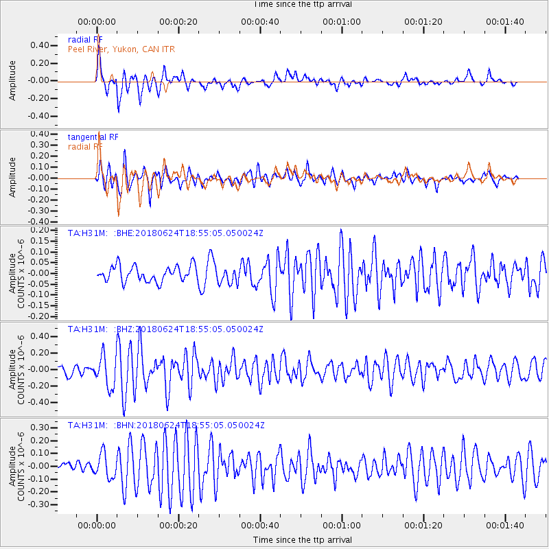
Signal To Noise
| Channel | StoN | STA | LTA |
| TA:H31M: :BHZ:20180624T18:55:05.050024Z | 3.7511392 | 1.9505148E-7 | 5.1997933E-8 |
| TA:H31M: :BHN:20180624T18:55:05.050024Z | 1.9868647 | 9.41355E-8 | 4.7378922E-8 |
| TA:H31M: :BHE:20180624T18:55:05.050024Z | 1.1135058 | 3.948868E-8 | 3.546338E-8 |
| Arrivals |
| Ps | 6.0 SECOND |
| PpPs | 16 SECOND |
| PsPs/PpSs | 22 SECOND |


