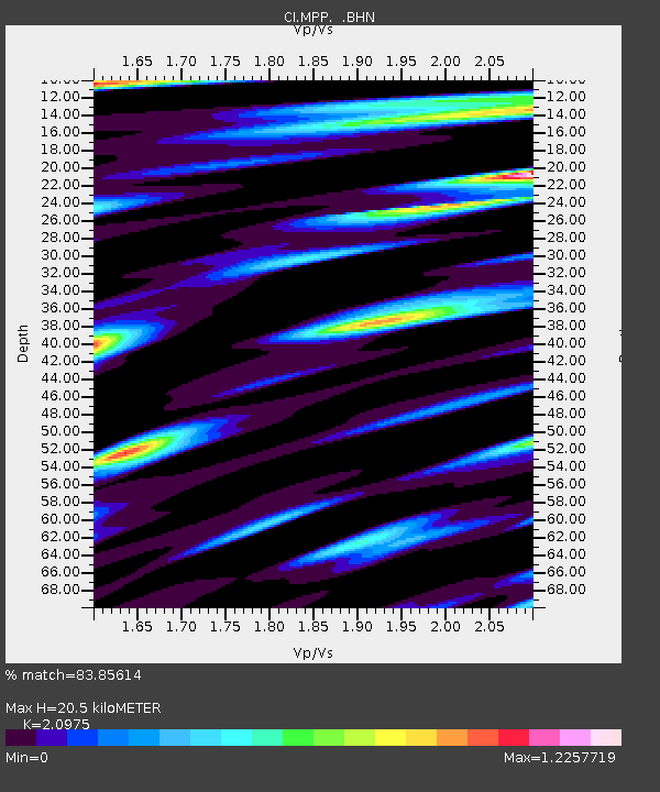
MPP McPhearson Peak - Earthquake Result Viewer
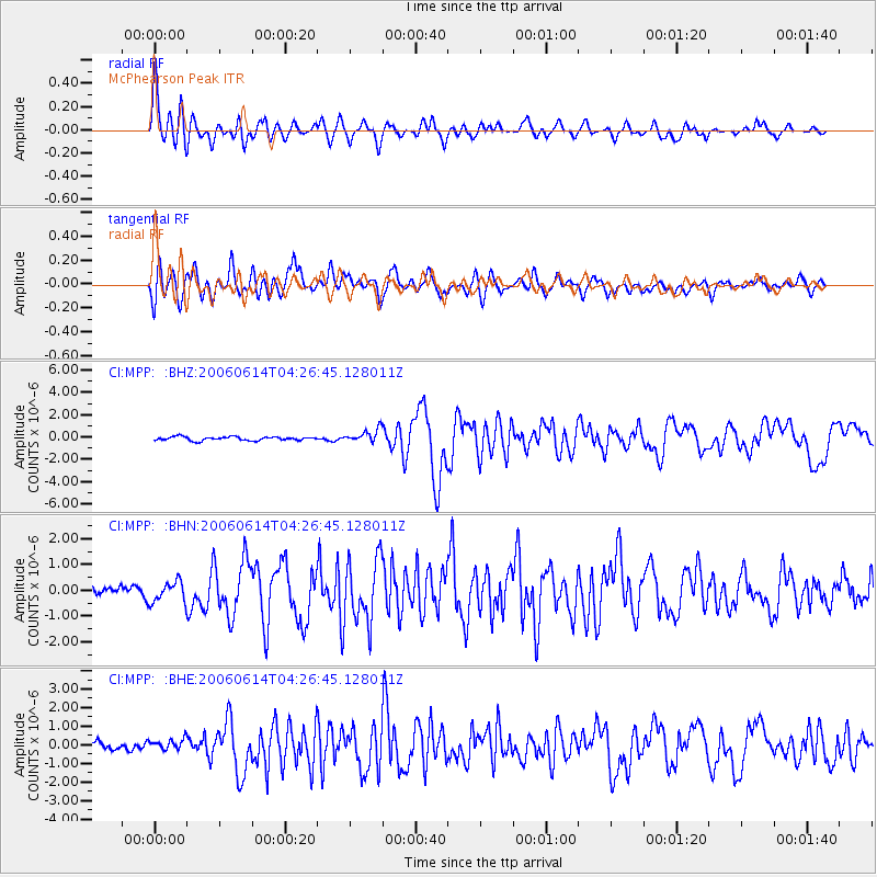
Earthquake location: Rat Islands, Aleutian Islands
Earthquake latitude/longitude: 51.8/177.1
Earthquake time(UTC): 2006/06/14 (165) 04:18:42 GMT
Earthquake Depth: 14 km
Earthquake Magnitude: 5.9 MB, 6.4 MS, 6.4 MW, 6.4 MW
Earthquake Catalog/Contributor: WHDF/NEIC
Network: CI Caltech Regional Seismic Network
Station: MPP McPhearson Peak
Lat/Lon: 34.89 N/119.81 W
Elevation: 1739 m
Distance: 47.4 deg
Az: 85.115 deg
Baz: 311.111 deg
Ray Param: 0.0700203
Estimated Moho Depth: 20.5 km
Estimated Crust Vp/Vs: 2.10
Assumed Crust Vp: 6.1 km/s
Estimated Crust Vs: 2.908 km/s
Estimated Crust Poisson's Ratio: 0.35
Radial Match: 83.85614 %
Radial Bump: 400
Transverse Match: 85.65284 %
Transverse Bump: 400
SOD ConfigId: 5745
Insert Time: 2010-02-26 02:02:10.884 +0000
GWidth: 2.5
Max Bumps: 400
Tol: 0.001

Signal To Noise

ChannelStoNSTALTA
CI:MPP: :BHN:20060614T04:26:45.128011Z1.77739914.0420275E-72.274125E-7
CI:MPP: :BHE:20060614T04:26:45.128011Z1.40904822.93068E-72.0799006E-7
CI:MPP: :BHZ:20060614T04:26:45.128011Z3.4955915.868766E-71.6789052E-7
Arrivals
Ps3.9 SECOND
PpPs9.9 SECOND
PsPs/PpSs14 SECOND