You are here: Home > Network List > TA - USArray Transportable Network (new EarthScope stations) Stations List
> Station H14A Leadore, ID, USA > Earthquake Result Viewer
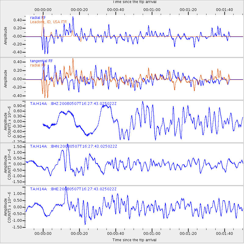
H14A Leadore, ID, USA - Earthquake Result Viewer
*The percent match for this event was below the threshold and hence no stack was calculated.
| Earthquake location: |
Near East Coast Of Honshu, Japan |
| Earthquake latitude/longitude: |
36.2/141.8 |
| Earthquake time(UTC): |
2008/05/07 (128) 16:16:36 GMT |
| Earthquake Depth: |
23 km |
| Earthquake Magnitude: |
5.9 MB, 6.1 MW, 6.0 MW |
| Earthquake Catalog/Contributor: |
WHDF/NEIC |
|
| Network: |
TA USArray Transportable Network (new EarthScope stations) |
| Station: |
H14A Leadore, ID, USA |
| Lat/Lon: |
44.62 N/113.37 W |
| Elevation: |
1933 m |
|
| Distance: |
74.8 deg |
| Az: |
45.674 deg |
| Baz: |
305.84 deg |
| Ray Param: |
$rayparam |
*The percent match for this event was below the threshold and hence was not used in the summary stack. |
|
| Radial Match: |
73.0329 % |
| Radial Bump: |
400 |
| Transverse Match: |
72.63664 % |
| Transverse Bump: |
400 |
| SOD ConfigId: |
2504 |
| Insert Time: |
2010-03-06 12:08:46.804 +0000 |
| GWidth: |
2.5 |
| Max Bumps: |
400 |
| Tol: |
0.001 |
|
Signal To Noise
| Channel | StoN | STA | LTA |
| TA:H14A: :BHN:20080507T16:27:43.025022Z | 1.4408169 | 5.496959E-7 | 3.8151683E-7 |
| TA:H14A: :BHE:20080507T16:27:43.025022Z | 1.9999443 | 4.1518612E-7 | 2.0759884E-7 |
| TA:H14A: :BHZ:20080507T16:27:43.025022Z | 1.6296871 | 6.9251143E-7 | 4.249352E-7 |
| Arrivals |
| Ps | |
| PpPs | |
| PsPs/PpSs | |


