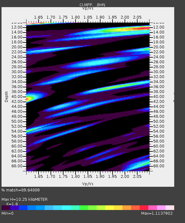
MPP McPhearson Peak - Earthquake Result Viewer
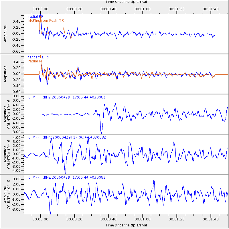
Earthquake location: Eastern Siberia, Russia
Earthquake latitude/longitude: 60.5/167.5
Earthquake time(UTC): 2006/04/29 (119) 16:58:06 GMT
Earthquake Depth: 11 km
Earthquake Magnitude: 6.4 MB, 6.6 MS, 6.6 MW, 6.4 MW
Earthquake Catalog/Contributor: WHDF/NEIC
Network: CI Caltech Regional Seismic Network
Station: MPP McPhearson Peak
Lat/Lon: 34.89 N/119.81 W
Elevation: 1739 m
Distance: 52.0 deg
Az: 84.965 deg
Baz: 323.137 deg
Ray Param: 0.06705422
Estimated Moho Depth: 10.25 km
Estimated Crust Vp/Vs: 1.60
Assumed Crust Vp: 6.1 km/s
Estimated Crust Vs: 3.812 km/s
Estimated Crust Poisson's Ratio: 0.18
Radial Match: 89.64889 %
Radial Bump: 400
Transverse Match: 82.91965 %
Transverse Bump: 400
SOD ConfigId: 2669
Insert Time: 2010-02-26 02:02:14.192 +0000
GWidth: 2.5
Max Bumps: 400
Tol: 0.001

Signal To Noise

ChannelStoNSTALTA
CI:MPP: :BHN:20060429T17:06:44.403008Z1.35305714.120869E-73.0455988E-7
CI:MPP: :BHE:20060429T17:06:44.403008Z1.45020446.114679E-74.2164257E-7
CI:MPP: :BHZ:20060429T17:06:44.403008Z3.20572047.7472146E-72.4166843E-7
Arrivals
Ps1.1 SECOND
PpPs4.1 SECOND
PsPs/PpSs5.2 SECOND