You are here: Home > Network List > TA - USArray Transportable Network (new EarthScope stations) Stations List
> Station H14A Leadore, ID, USA > Earthquake Result Viewer
H14A Leadore, ID, USA - Earthquake Result Viewer
*The percent match for this event was below the threshold and hence no stack was calculated.
| Earthquake location: |
Santa Cruz Islands |
| Earthquake latitude/longitude: |
-11.8/166.5 |
| Earthquake time(UTC): |
2008/09/09 (253) 23:18:26 GMT |
| Earthquake Depth: |
99 km |
| Earthquake Magnitude: |
5.6 MW, 5.4 MB, 5.6 MW |
| Earthquake Catalog/Contributor: |
WHDF/NEIC |
|
| Network: |
TA USArray Transportable Network (new EarthScope stations) |
| Station: |
H14A Leadore, ID, USA |
| Lat/Lon: |
44.62 N/113.37 W |
| Elevation: |
1933 m |
|
| Distance: |
91.3 deg |
| Az: |
44.73 deg |
| Baz: |
254.768 deg |
| Ray Param: |
$rayparam |
*The percent match for this event was below the threshold and hence was not used in the summary stack. |
|
| Radial Match: |
72.91325 % |
| Radial Bump: |
400 |
| Transverse Match: |
59.825314 % |
| Transverse Bump: |
400 |
| SOD ConfigId: |
2560 |
| Insert Time: |
2010-03-06 12:09:49.300 +0000 |
| GWidth: |
2.5 |
| Max Bumps: |
400 |
| Tol: |
0.001 |
|
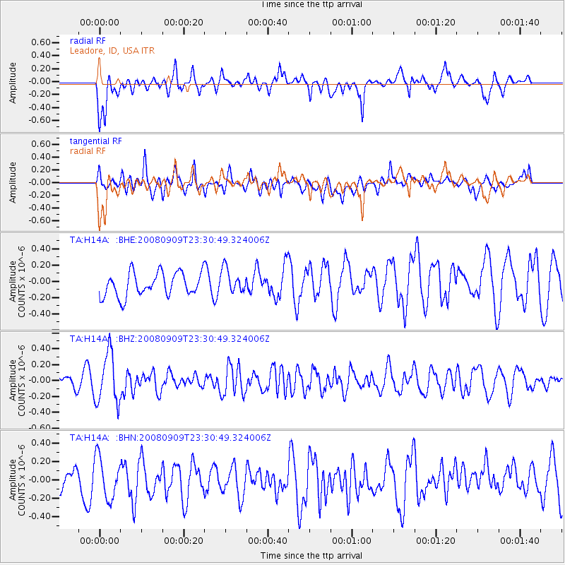
Signal To Noise
| Channel | StoN | STA | LTA |
| TA:H14A: :BHZ:20080909T23:30:49.324006Z | 2.6200914 | 3.2146937E-7 | 1.2269396E-7 |
| TA:H14A: :BHN:20080909T23:30:49.324006Z | 1.8547424 | 2.2997048E-7 | 1.2399053E-7 |
| TA:H14A: :BHE:20080909T23:30:49.324006Z | 1.046526 | 1.5222196E-7 | 1.4545454E-7 |
| Arrivals |
| Ps | |
| PpPs | |
| PsPs/PpSs | |


