You are here: Home > Network List > TA - USArray Transportable Network (new EarthScope stations) Stations List
> Station H14A Leadore, ID, USA > Earthquake Result Viewer
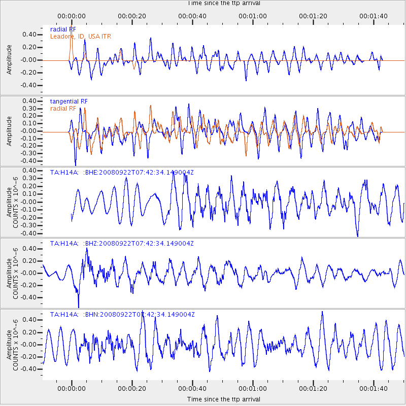
H14A Leadore, ID, USA - Earthquake Result Viewer
*The percent match for this event was below the threshold and hence no stack was calculated.
| Earthquake location: |
Hokkaido, Japan Region |
| Earthquake latitude/longitude: |
41.6/140.4 |
| Earthquake time(UTC): |
2008/09/22 (266) 07:31:59 GMT |
| Earthquake Depth: |
149 km |
| Earthquake Magnitude: |
5.7 MW, 5.3 MB, 5.6 MW |
| Earthquake Catalog/Contributor: |
WHDF/NEIC |
|
| Network: |
TA USArray Transportable Network (new EarthScope stations) |
| Station: |
H14A Leadore, ID, USA |
| Lat/Lon: |
44.62 N/113.37 W |
| Elevation: |
1933 m |
|
| Distance: |
71.7 deg |
| Az: |
46.243 deg |
| Baz: |
310.644 deg |
| Ray Param: |
$rayparam |
*The percent match for this event was below the threshold and hence was not used in the summary stack. |
|
| Radial Match: |
60.886837 % |
| Radial Bump: |
400 |
| Transverse Match: |
58.91385 % |
| Transverse Bump: |
400 |
| SOD ConfigId: |
2560 |
| Insert Time: |
2010-03-06 12:09:51.297 +0000 |
| GWidth: |
2.5 |
| Max Bumps: |
400 |
| Tol: |
0.001 |
|
Signal To Noise
| Channel | StoN | STA | LTA |
| TA:H14A: :BHZ:20080922T07:42:34.149004Z | 1.940342 | 2.1312482E-7 | 1.0983879E-7 |
| TA:H14A: :BHN:20080922T07:42:34.149004Z | 0.89960474 | 1.5075264E-7 | 1.6757653E-7 |
| TA:H14A: :BHE:20080922T07:42:34.149004Z | 1.4004601 | 1.9907044E-7 | 1.4214646E-7 |
| Arrivals |
| Ps | |
| PpPs | |
| PsPs/PpSs | |


