You are here: Home > Network List > TA - USArray Transportable Network (new EarthScope stations) Stations List
> Station H14A Leadore, ID, USA > Earthquake Result Viewer
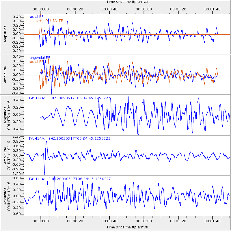
H14A Leadore, ID, USA - Earthquake Result Viewer
*The percent match for this event was below the threshold and hence no stack was calculated.
| Earthquake location: |
Tonga Islands |
| Earthquake latitude/longitude: |
-16.8/-173.5 |
| Earthquake time(UTC): |
2009/05/17 (137) 06:23:03 GMT |
| Earthquake Depth: |
67 km |
| Earthquake Magnitude: |
5.5 MB, 5.6 MW, 5.6 MW |
| Earthquake Catalog/Contributor: |
WHDF/NEIC |
|
| Network: |
TA USArray Transportable Network (new EarthScope stations) |
| Station: |
H14A Leadore, ID, USA |
| Lat/Lon: |
44.62 N/113.37 W |
| Elevation: |
1933 m |
|
| Distance: |
82.0 deg |
| Az: |
38.709 deg |
| Baz: |
236.996 deg |
| Ray Param: |
$rayparam |
*The percent match for this event was below the threshold and hence was not used in the summary stack. |
|
| Radial Match: |
61.7053 % |
| Radial Bump: |
400 |
| Transverse Match: |
77.32301 % |
| Transverse Bump: |
400 |
| SOD ConfigId: |
2760 |
| Insert Time: |
2010-03-06 12:10:04.171 +0000 |
| GWidth: |
2.5 |
| Max Bumps: |
400 |
| Tol: |
0.001 |
|
Signal To Noise
| Channel | StoN | STA | LTA |
| TA:H14A: :BHZ:20090517T06:34:45.125022Z | 2.8426666 | 4.8625344E-7 | 1.7105539E-7 |
| TA:H14A: :BHN:20090517T06:34:45.125022Z | 1.2547947 | 1.9074105E-7 | 1.5200976E-7 |
| TA:H14A: :BHE:20090517T06:34:45.125022Z | 1.2498966 | 1.8166983E-7 | 1.453479E-7 |
| Arrivals |
| Ps | |
| PpPs | |
| PsPs/PpSs | |


