You are here: Home > Network List > TA - USArray Transportable Network (new EarthScope stations) Stations List
> Station M17A Scullys Gap (BLM), Evanston, WY, USA > Earthquake Result Viewer
M17A Scullys Gap (BLM), Evanston, WY, USA - Earthquake Result Viewer
| Earthquake location: |
Southeast Of Honshu, Japan |
| Earthquake latitude/longitude: |
32.8/140.4 |
| Earthquake time(UTC): |
2009/08/12 (224) 22:48:51 GMT |
| Earthquake Depth: |
53 km |
| Earthquake Magnitude: |
6.2 MB, 6.6 MW, 6.6 MW |
| Earthquake Catalog/Contributor: |
WHDF/NEIC |
|
| Network: |
TA USArray Transportable Network (new EarthScope stations) |
| Station: |
M17A Scullys Gap (BLM), Evanston, WY, USA |
| Lat/Lon: |
41.47 N/110.67 W |
| Elevation: |
2101 m |
|
| Distance: |
81.3 deg |
| Az: |
45.971 deg |
| Baz: |
306.33 deg |
| Ray Param: |
0.047557324 |
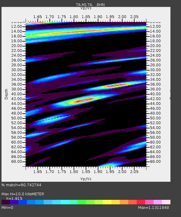
| Estimated Moho Depth: |
10.0 km |
| Estimated Crust Vp/Vs: |
1.62 |
| Assumed Crust Vp: |
6.155 km/s |
| Estimated Crust Vs: |
3.811 km/s |
| Estimated Crust Poisson's Ratio: |
0.19 |
|
| Radial Match: |
90.742744 % |
| Radial Bump: |
400 |
| Transverse Match: |
83.83687 % |
| Transverse Bump: |
400 |
| SOD ConfigId: |
2622 |
| Insert Time: |
2010-03-06 12:10:20.296 +0000 |
| GWidth: |
2.5 |
| Max Bumps: |
400 |
| Tol: |
0.001 |
|

Signal To Noise
| Channel | StoN | STA | LTA |
| TA:M17A: :BHN:20090812T23:00:31.200029Z | 52.82983 | 3.9394386E-6 | 7.456845E-8 |
| TA:M17A: :BHE:20090812T23:00:31.200029Z | 8.235896 | 6.960078E-7 | 8.4509054E-8 |
| TA:M17A: :BHZ:20090812T23:00:31.200029Z | 5.566575 | 8.107135E-7 | 1.4563955E-7 |
| Arrivals |
| Ps | 1.0 SECOND |
| PpPs | 4.1 SECOND |
| PsPs/PpSs | 5.2 SECOND |


