You are here: Home > Network List > TA - USArray Transportable Network (new EarthScope stations) Stations List
> Station G18K Tagagawik, AK, USA > Earthquake Result Viewer
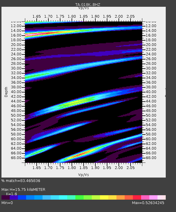
G18K Tagagawik, AK, USA - Earthquake Result Viewer
| Earthquake location: |
Galapagos Islands, Ecuador |
| Earthquake latitude/longitude: |
-0.7/-90.9 |
| Earthquake time(UTC): |
2018/06/26 (177) 09:15:36 GMT |
| Earthquake Depth: |
10 km |
| Earthquake Magnitude: |
5.5 Mww |
| Earthquake Catalog/Contributor: |
NEIC PDE/us |
|
| Network: |
TA USArray Transportable Network (new EarthScope stations) |
| Station: |
G18K Tagagawik, AK, USA |
| Lat/Lon: |
65.89 N/158.65 W |
| Elevation: |
484 m |
|
| Distance: |
81.7 deg |
| Az: |
337.413 deg |
| Baz: |
110.753 deg |
| Ray Param: |
0.047425814 |
| Estimated Moho Depth: |
15.75 km |
| Estimated Crust Vp/Vs: |
1.60 |
| Assumed Crust Vp: |
6.1 km/s |
| Estimated Crust Vs: |
3.812 km/s |
| Estimated Crust Poisson's Ratio: |
0.18 |
|
| Radial Match: |
83.465836 % |
| Radial Bump: |
400 |
| Transverse Match: |
71.499245 % |
| Transverse Bump: |
400 |
| SOD ConfigId: |
13570011 |
| Insert Time: |
2019-04-30 11:41:25.502 +0000 |
| GWidth: |
2.5 |
| Max Bumps: |
400 |
| Tol: |
0.001 |
|

Signal To Noise
| Channel | StoN | STA | LTA |
| TA:G18K: :BHZ:20180626T09:27:23.72501Z | 2.507553 | 1.4339211E-7 | 5.718408E-8 |
| TA:G18K: :BHN:20180626T09:27:23.72501Z | 2.0354776 | 7.736238E-8 | 3.800699E-8 |
| TA:G18K: :BHE:20180626T09:27:23.72501Z | 1.3451943 | 4.1317467E-8 | 3.071487E-8 |
| Arrivals |
| Ps | 1.6 SECOND |
| PpPs | 6.5 SECOND |
| PsPs/PpSs | 8.1 SECOND |


