You are here: Home > Network List > TA - USArray Transportable Network (new EarthScope stations) Stations List
> Station G31M Satah River, YT, CAN > Earthquake Result Viewer
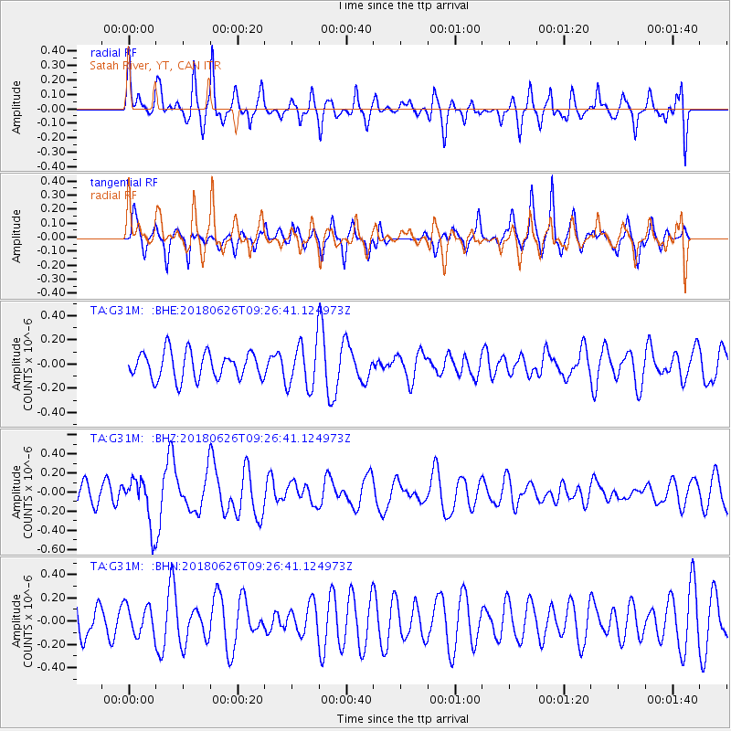
G31M Satah River, YT, CAN - Earthquake Result Viewer
*The percent match for this event was below the threshold and hence no stack was calculated.
| Earthquake location: |
Galapagos Islands, Ecuador |
| Earthquake latitude/longitude: |
-0.7/-90.9 |
| Earthquake time(UTC): |
2018/06/26 (177) 09:15:36 GMT |
| Earthquake Depth: |
10 km |
| Earthquake Magnitude: |
5.5 Mww |
| Earthquake Catalog/Contributor: |
NEIC PDE/us |
|
| Network: |
TA USArray Transportable Network (new EarthScope stations) |
| Station: |
G31M Satah River, YT, CAN |
| Lat/Lon: |
66.92 N/134.27 W |
| Elevation: |
61 m |
|
| Distance: |
74.0 deg |
| Az: |
343.654 deg |
| Baz: |
134.45 deg |
| Ray Param: |
$rayparam |
*The percent match for this event was below the threshold and hence was not used in the summary stack. |
|
| Radial Match: |
68.84192 % |
| Radial Bump: |
400 |
| Transverse Match: |
70.83254 % |
| Transverse Bump: |
396 |
| SOD ConfigId: |
13570011 |
| Insert Time: |
2019-04-30 11:41:33.690 +0000 |
| GWidth: |
2.5 |
| Max Bumps: |
400 |
| Tol: |
0.001 |
|
Signal To Noise
| Channel | StoN | STA | LTA |
| TA:G31M: :BHZ:20180626T09:26:41.124973Z | 1.6233598 | 2.5075775E-7 | 1.5446838E-7 |
| TA:G31M: :BHN:20180626T09:26:41.124973Z | 0.63982034 | 1.253979E-7 | 1.9598924E-7 |
| TA:G31M: :BHE:20180626T09:26:41.124973Z | 1.6797891 | 1.8839744E-7 | 1.1215541E-7 |
| Arrivals |
| Ps | |
| PpPs | |
| PsPs/PpSs | |


