You are here: Home > Network List > TA - USArray Transportable Network (new EarthScope stations) Stations List
> Station I30M Mount Dempster, Yukon, CAN > Earthquake Result Viewer
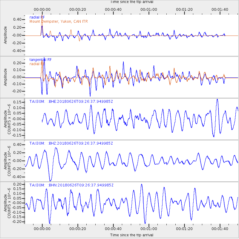
I30M Mount Dempster, Yukon, CAN - Earthquake Result Viewer
*The percent match for this event was below the threshold and hence no stack was calculated.
| Earthquake location: |
Galapagos Islands, Ecuador |
| Earthquake latitude/longitude: |
-0.7/-90.9 |
| Earthquake time(UTC): |
2018/06/26 (177) 09:15:36 GMT |
| Earthquake Depth: |
10 km |
| Earthquake Magnitude: |
5.5 Mww |
| Earthquake Catalog/Contributor: |
NEIC PDE/us |
|
| Network: |
TA USArray Transportable Network (new EarthScope stations) |
| Station: |
I30M Mount Dempster, Yukon, CAN |
| Lat/Lon: |
65.22 N/136.38 W |
| Elevation: |
1399 m |
|
| Distance: |
73.4 deg |
| Az: |
341.745 deg |
| Baz: |
131.991 deg |
| Ray Param: |
$rayparam |
*The percent match for this event was below the threshold and hence was not used in the summary stack. |
|
| Radial Match: |
74.20996 % |
| Radial Bump: |
400 |
| Transverse Match: |
68.24873 % |
| Transverse Bump: |
400 |
| SOD ConfigId: |
13570011 |
| Insert Time: |
2019-04-30 11:41:49.763 +0000 |
| GWidth: |
2.5 |
| Max Bumps: |
400 |
| Tol: |
0.001 |
|
Signal To Noise
| Channel | StoN | STA | LTA |
| TA:I30M: :BHZ:20180626T09:26:37.949985Z | 3.0632179 | 2.49954E-7 | 8.1598515E-8 |
| TA:I30M: :BHN:20180626T09:26:37.949985Z | 2.132656 | 1.0868859E-7 | 5.0963955E-8 |
| TA:I30M: :BHE:20180626T09:26:37.949985Z | 1.6929939 | 6.679673E-8 | 3.9454797E-8 |
| Arrivals |
| Ps | |
| PpPs | |
| PsPs/PpSs | |


