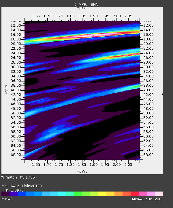
MPP McPhearson Peak - Earthquake Result Viewer
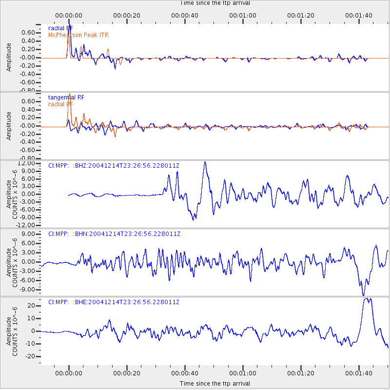
Earthquake location: Caribbean Sea
Earthquake latitude/longitude: 19.0/-81.4
Earthquake time(UTC): 2004/12/14 (349) 23:20:13 GMT
Earthquake Depth: 10 km
Earthquake Magnitude: 6.2 MB, 6.7 MS, 6.8 MW, 6.8 MW
Earthquake Catalog/Contributor: WHDF/NEIC
Network: CI Caltech Regional Seismic Network
Station: MPP McPhearson Peak
Lat/Lon: 34.89 N/119.81 W
Elevation: 1739 m
Distance: 37.5 deg
Az: 302.939 deg
Baz: 104.936 deg
Ray Param: 0.07611291
Estimated Moho Depth: 16.0 km
Estimated Crust Vp/Vs: 1.90
Assumed Crust Vp: 6.1 km/s
Estimated Crust Vs: 3.215 km/s
Estimated Crust Poisson's Ratio: 0.31
Radial Match: 93.1735 %
Radial Bump: 293
Transverse Match: 65.5575 %
Transverse Bump: 400
SOD ConfigId: 2459
Insert Time: 2010-02-26 02:02:21.159 +0000
GWidth: 2.5
Max Bumps: 400
Tol: 0.001

Signal To Noise

ChannelStoNSTALTA
CI:MPP: :BHN:20041214T23:26:56.228011Z1.5330221.1026143E-67.192423E-7
CI:MPP: :BHE:20041214T23:26:56.228011Z4.94930361.5038989E-63.038607E-7
CI:MPP: :BHZ:20041214T23:26:56.228011Z8.0851812.7535307E-63.4056512E-7
Arrivals
Ps2.5 SECOND
PpPs7.1 SECOND
PsPs/PpSs9.7 SECOND