You are here: Home > Network List > TA - USArray Transportable Network (new EarthScope stations) Stations List
> Station M17A Scullys Gap (BLM), Evanston, WY, USA > Earthquake Result Viewer
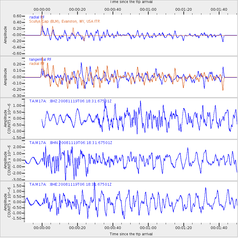
M17A Scullys Gap (BLM), Evanston, WY, USA - Earthquake Result Viewer
*The percent match for this event was below the threshold and hence no stack was calculated.
| Earthquake location: |
Panama-Costa Rica Border Region |
| Earthquake latitude/longitude: |
8.3/-83.0 |
| Earthquake time(UTC): |
2008/11/19 (324) 06:11:20 GMT |
| Earthquake Depth: |
32 km |
| Earthquake Magnitude: |
5.9 MB, 5.9 MS, 6.2 MW, 6.1 MW |
| Earthquake Catalog/Contributor: |
WHDF/NEIC |
|
| Network: |
TA USArray Transportable Network (new EarthScope stations) |
| Station: |
M17A Scullys Gap (BLM), Evanston, WY, USA |
| Lat/Lon: |
41.47 N/110.67 W |
| Elevation: |
2101 m |
|
| Distance: |
41.2 deg |
| Az: |
327.952 deg |
| Baz: |
135.662 deg |
| Ray Param: |
$rayparam |
*The percent match for this event was below the threshold and hence was not used in the summary stack. |
|
| Radial Match: |
66.465904 % |
| Radial Bump: |
400 |
| Transverse Match: |
57.9372 % |
| Transverse Bump: |
400 |
| SOD ConfigId: |
2658 |
| Insert Time: |
2010-03-06 12:11:40.117 +0000 |
| GWidth: |
2.5 |
| Max Bumps: |
400 |
| Tol: |
0.001 |
|
Signal To Noise
| Channel | StoN | STA | LTA |
| TA:M17A: :BHN:20081119T06:18:31.67501Z | 3.4313726 | 7.402049E-7 | 2.1571685E-7 |
| TA:M17A: :BHE:20081119T06:18:31.67501Z | 1.8970652 | 3.632388E-7 | 1.9147407E-7 |
| TA:M17A: :BHZ:20081119T06:18:31.67501Z | 1.0922079 | 3.789451E-7 | 3.4695324E-7 |
| Arrivals |
| Ps | |
| PpPs | |
| PsPs/PpSs | |


