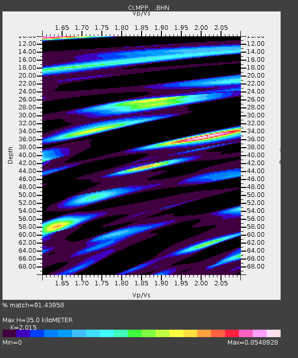
MPP McPhearson Peak - Earthquake Result Viewer

Earthquake location: Hokkaido, Japan Region
Earthquake latitude/longitude: 43.0/145.1
Earthquake time(UTC): 2004/11/28 (333) 18:32:14 GMT
Earthquake Depth: 39 km
Earthquake Magnitude: 6.4 MB, 6.7 MS, 7.0 MW, 7.0 MW
Earthquake Catalog/Contributor: WHDF/NEIC
Network: CI Caltech Regional Seismic Network
Station: MPP McPhearson Peak
Lat/Lon: 34.89 N/119.81 W
Elevation: 1739 m
Distance: 70.5 deg
Az: 60.302 deg
Baz: 309.183 deg
Ray Param: 0.0548715
Estimated Moho Depth: 35.0 km
Estimated Crust Vp/Vs: 2.02
Assumed Crust Vp: 6.1 km/s
Estimated Crust Vs: 3.027 km/s
Estimated Crust Poisson's Ratio: 0.34
Radial Match: 91.43958 %
Radial Bump: 356
Transverse Match: 79.438255 %
Transverse Bump: 400
SOD ConfigId: 2459
Insert Time: 2010-02-26 02:02:22.888 +0000
GWidth: 2.5
Max Bumps: 400
Tol: 0.001

Signal To Noise

ChannelStoNSTALTA
CI:MPP: :BHN:20041128T18:42:53.952021Z2.7898781.4327455E-65.1355136E-7
CI:MPP: :BHE:20041128T18:42:53.952021Z1.59485411.3927026E-68.732477E-7
CI:MPP: :BHZ:20041128T18:42:53.952021Z6.7671153.7560756E-65.5504825E-7
Arrivals
Ps6.0 SECOND
PpPs17 SECOND
PsPs/PpSs23 SECOND