You are here: Home > Network List > TA - USArray Transportable Network (new EarthScope stations) Stations List
> Station M17A Scullys Gap (BLM), Evanston, WY, USA > Earthquake Result Viewer
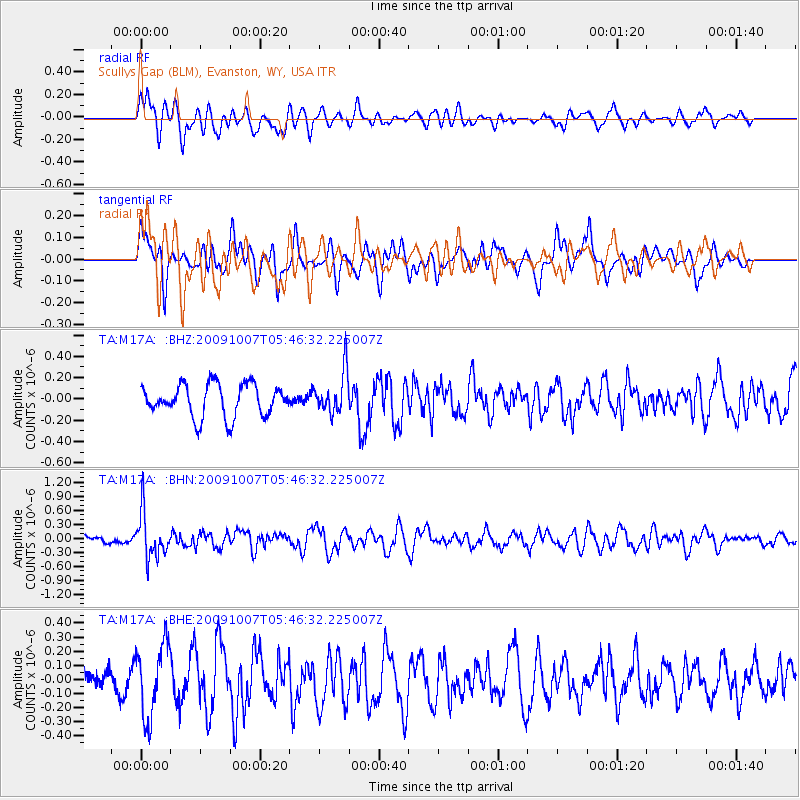
M17A Scullys Gap (BLM), Evanston, WY, USA - Earthquake Result Viewer
*The percent match for this event was below the threshold and hence no stack was calculated.
| Earthquake location: |
Rat Islands, Aleutian Islands |
| Earthquake latitude/longitude: |
52.2/178.1 |
| Earthquake time(UTC): |
2009/10/07 (280) 05:38:37 GMT |
| Earthquake Depth: |
138 km |
| Earthquake Magnitude: |
5.6 MB, 5.6 MW, 5.6 MW |
| Earthquake Catalog/Contributor: |
WHDF/NEIC |
|
| Network: |
TA USArray Transportable Network (new EarthScope stations) |
| Station: |
M17A Scullys Gap (BLM), Evanston, WY, USA |
| Lat/Lon: |
41.47 N/110.67 W |
| Elevation: |
2101 m |
|
| Distance: |
48.1 deg |
| Az: |
73.081 deg |
| Baz: |
308.341 deg |
| Ray Param: |
$rayparam |
*The percent match for this event was below the threshold and hence was not used in the summary stack. |
|
| Radial Match: |
63.499893 % |
| Radial Bump: |
400 |
| Transverse Match: |
46.330738 % |
| Transverse Bump: |
388 |
| SOD ConfigId: |
2622 |
| Insert Time: |
2010-03-06 12:12:07.011 +0000 |
| GWidth: |
2.5 |
| Max Bumps: |
400 |
| Tol: |
0.001 |
|
Signal To Noise
| Channel | StoN | STA | LTA |
| TA:M17A: :BHN:20091007T05:46:32.225007Z | 3.7269495 | 4.7801757E-7 | 1.2825974E-7 |
| TA:M17A: :BHE:20091007T05:46:32.225007Z | 2.559832 | 2.5800767E-7 | 1.0079086E-7 |
| TA:M17A: :BHZ:20091007T05:46:32.225007Z | 1.2564846 | 1.9120789E-7 | 1.5217687E-7 |
| Arrivals |
| Ps | |
| PpPs | |
| PsPs/PpSs | |


