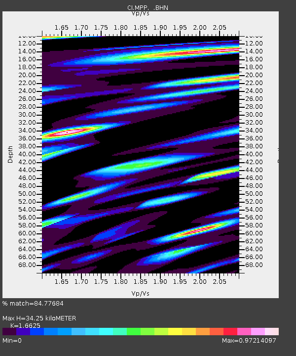
MPP McPhearson Peak - Earthquake Result Viewer
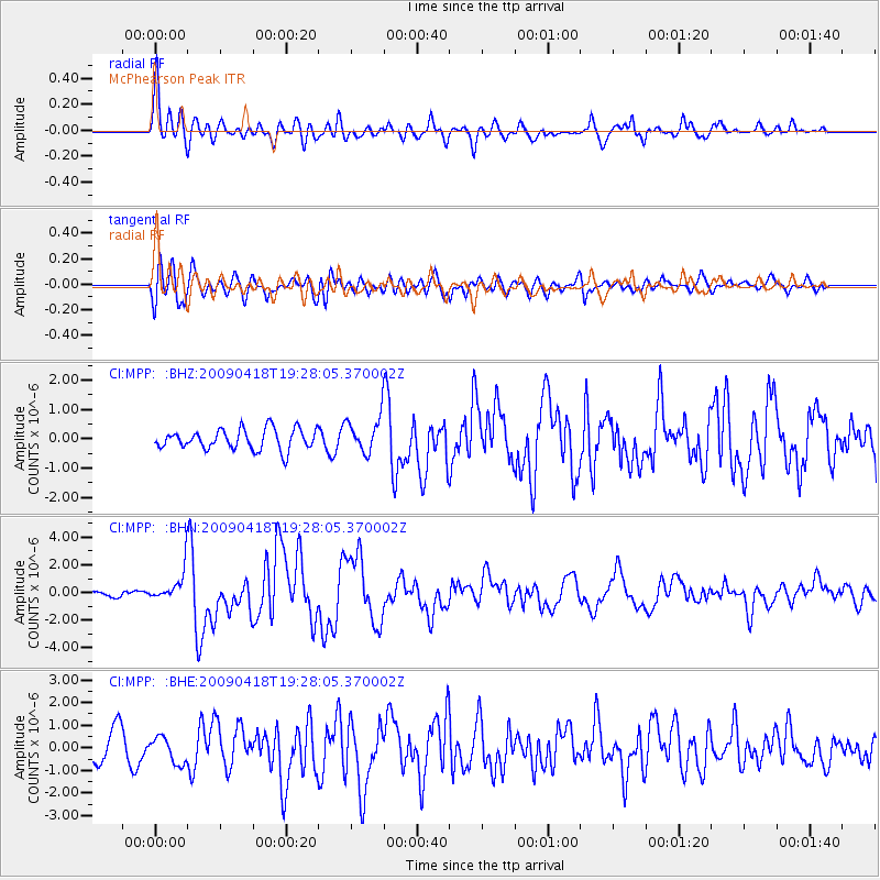
Earthquake location: Kuril Islands
Earthquake latitude/longitude: 46.0/151.4
Earthquake time(UTC): 2009/04/18 (108) 19:17:58 GMT
Earthquake Depth: 35 km
Earthquake Magnitude: 6.3 MB, 6.3 MS, 6.6 MW, 6.4 MW
Earthquake Catalog/Contributor: WHDF/NEIC
Network: CI Caltech Regional Seismic Network
Station: MPP McPhearson Peak
Lat/Lon: 34.89 N/119.81 W
Elevation: 1739 m
Distance: 65.1 deg
Az: 64.955 deg
Baz: 309.824 deg
Ray Param: 0.058424607
Estimated Moho Depth: 34.25 km
Estimated Crust Vp/Vs: 1.66
Assumed Crust Vp: 6.1 km/s
Estimated Crust Vs: 3.669 km/s
Estimated Crust Poisson's Ratio: 0.22
Radial Match: 84.77684 %
Radial Bump: 400
Transverse Match: 67.334816 %
Transverse Bump: 400
SOD ConfigId: 2760
Insert Time: 2010-02-26 02:02:25.848 +0000
GWidth: 2.5
Max Bumps: 400
Tol: 0.001

Signal To Noise

ChannelStoNSTALTA
CI:MPP: :BHN:20090418T19:28:05.370002Z4.1054021.1237192E-62.737172E-7
CI:MPP: :BHE:20090418T19:28:05.370002Z0.76813015.721899E-77.4491277E-7
CI:MPP: :BHZ:20090418T19:28:05.370002Z1.76362626.1302967E-73.4759614E-7
Arrivals
Ps3.9 SECOND
PpPs14 SECOND
PsPs/PpSs18 SECOND