You are here: Home > Network List > 5H - Central Virginia and South Carolina seismic monitoring experiment Stations List
> Station DEBI Ferncliff, VA > Earthquake Result Viewer
DEBI Ferncliff, VA - Earthquake Result Viewer
| Earthquake location: |
Near Coast Of Jalisco, Mexico |
| Earthquake latitude/longitude: |
19.1/-105.1 |
| Earthquake time(UTC): |
2018/06/30 (181) 03:56:50 GMT |
| Earthquake Depth: |
15 km |
| Earthquake Magnitude: |
5.9 Mww |
| Earthquake Catalog/Contributor: |
NEIC PDE/us |
|
| Network: |
5H Central Virginia and South Carolina seismic monitoring experiment |
| Station: |
DEBI Ferncliff, VA |
| Lat/Lon: |
37.92 N/78.10 W |
| Elevation: |
137 m |
|
| Distance: |
30.1 deg |
| Az: |
45.736 deg |
| Baz: |
238.923 deg |
| Ray Param: |
0.0794126 |
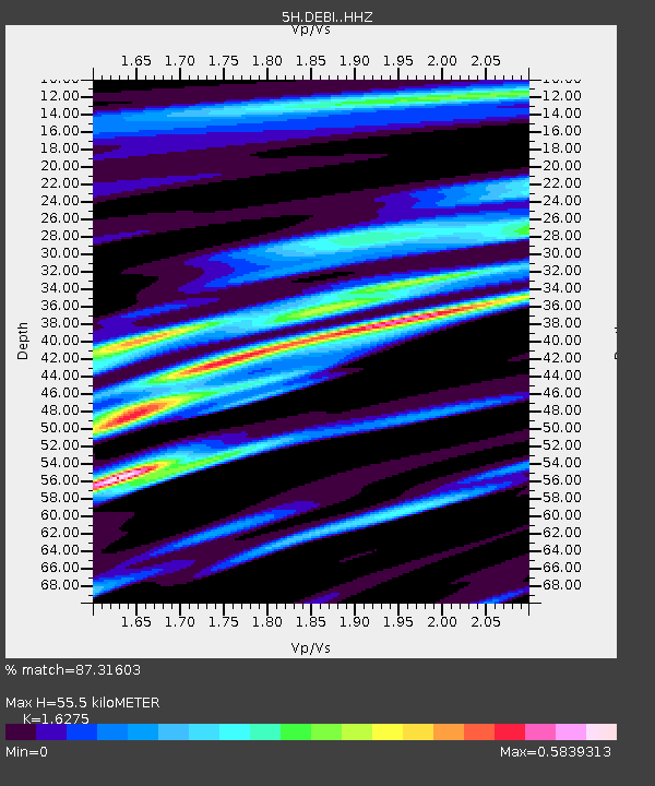
| Estimated Moho Depth: |
55.5 km |
| Estimated Crust Vp/Vs: |
1.63 |
| Assumed Crust Vp: |
6.419 km/s |
| Estimated Crust Vs: |
3.944 km/s |
| Estimated Crust Poisson's Ratio: |
0.20 |
|
| Radial Match: |
87.31603 % |
| Radial Bump: |
316 |
| Transverse Match: |
59.766518 % |
| Transverse Bump: |
400 |
| SOD ConfigId: |
13570011 |
| Insert Time: |
2019-04-30 11:50:37.667 +0000 |
| GWidth: |
2.5 |
| Max Bumps: |
400 |
| Tol: |
0.001 |
|

Signal To Noise
| Channel | StoN | STA | LTA |
| 5H:DEBI: :HHZ:20180630T04:02:27.939985Z | 4.5842657 | 3.1302562E-7 | 6.828261E-8 |
| 5H:DEBI: :HHN:20180630T04:02:27.939985Z | 2.2997622 | 1.226624E-7 | 5.3336993E-8 |
| 5H:DEBI: :HHE:20180630T04:02:27.939985Z | 4.0986037 | 2.0178949E-7 | 4.923372E-8 |
| Arrivals |
| Ps | 5.9 SECOND |
| PpPs | 21 SECOND |
| PsPs/PpSs | 27 SECOND |


