You are here: Home > Network List > 5H - Central Virginia and South Carolina seismic monitoring experiment Stations List
> Station PWTN Powhatan W.M.A., VA > Earthquake Result Viewer
PWTN Powhatan W.M.A., VA - Earthquake Result Viewer
| Earthquake location: |
Near Coast Of Jalisco, Mexico |
| Earthquake latitude/longitude: |
19.1/-105.1 |
| Earthquake time(UTC): |
2018/06/30 (181) 03:56:50 GMT |
| Earthquake Depth: |
15 km |
| Earthquake Magnitude: |
5.9 Mww |
| Earthquake Catalog/Contributor: |
NEIC PDE/us |
|
| Network: |
5H Central Virginia and South Carolina seismic monitoring experiment |
| Station: |
PWTN Powhatan W.M.A., VA |
| Lat/Lon: |
37.53 N/77.99 W |
| Elevation: |
99 m |
|
| Distance: |
30.0 deg |
| Az: |
46.495 deg |
| Baz: |
239.649 deg |
| Ray Param: |
0.07944448 |
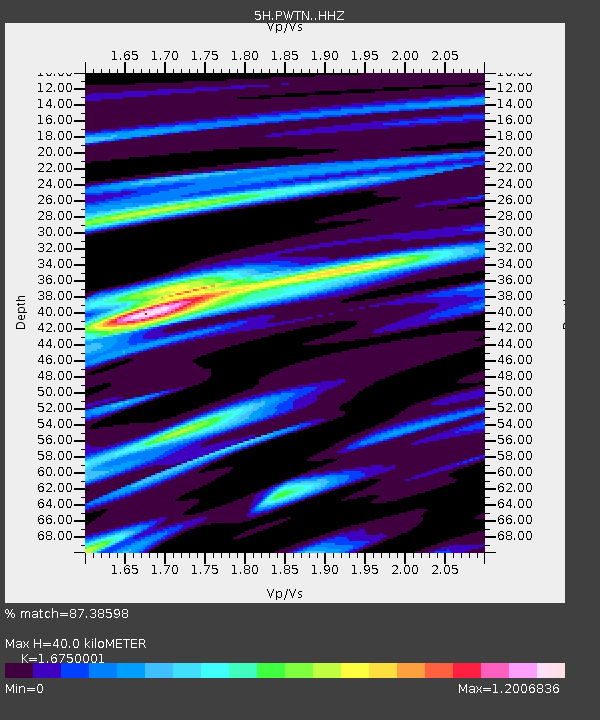
| Estimated Moho Depth: |
40.0 km |
| Estimated Crust Vp/Vs: |
1.68 |
| Assumed Crust Vp: |
6.565 km/s |
| Estimated Crust Vs: |
3.919 km/s |
| Estimated Crust Poisson's Ratio: |
0.22 |
|
| Radial Match: |
87.38598 % |
| Radial Bump: |
334 |
| Transverse Match: |
62.206673 % |
| Transverse Bump: |
400 |
| SOD ConfigId: |
13570011 |
| Insert Time: |
2019-04-30 11:50:39.945 +0000 |
| GWidth: |
2.5 |
| Max Bumps: |
400 |
| Tol: |
0.001 |
|

Signal To Noise
| Channel | StoN | STA | LTA |
| 5H:PWTN: :HHZ:20180630T04:02:26.865004Z | 6.679547 | 3.30034E-7 | 4.940964E-8 |
| 5H:PWTN: :HHN:20180630T04:02:26.865004Z | 1.6096249 | 7.374135E-8 | 4.5812754E-8 |
| 5H:PWTN: :HHE:20180630T04:02:26.865004Z | 3.9779136 | 2.1977193E-7 | 5.5248044E-8 |
| Arrivals |
| Ps | 4.5 SECOND |
| PpPs | 15 SECOND |
| PsPs/PpSs | 19 SECOND |


