You are here: Home > Network List > TA - USArray Transportable Network (new EarthScope stations) Stations List
> Station M17A Scullys Gap (BLM), Evanston, WY, USA > Earthquake Result Viewer
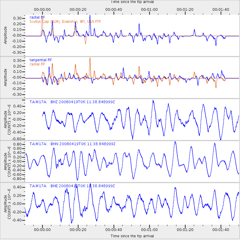
M17A Scullys Gap (BLM), Evanston, WY, USA - Earthquake Result Viewer
*The percent match for this event was below the threshold and hence no stack was calculated.
| Earthquake location: |
Loyalty Islands |
| Earthquake latitude/longitude: |
-20.3/168.8 |
| Earthquake time(UTC): |
2008/04/19 (110) 05:58:42 GMT |
| Earthquake Depth: |
14 km |
| Earthquake Magnitude: |
5.7 MB, 6.2 MS, 6.3 MW, 6.2 MW |
| Earthquake Catalog/Contributor: |
WHDF/NEIC |
|
| Network: |
TA USArray Transportable Network (new EarthScope stations) |
| Station: |
M17A Scullys Gap (BLM), Evanston, WY, USA |
| Lat/Lon: |
41.47 N/110.67 W |
| Elevation: |
2101 m |
|
| Distance: |
96.4 deg |
| Az: |
48.235 deg |
| Baz: |
248.72 deg |
| Ray Param: |
$rayparam |
*The percent match for this event was below the threshold and hence was not used in the summary stack. |
|
| Radial Match: |
67.757484 % |
| Radial Bump: |
343 |
| Transverse Match: |
46.312317 % |
| Transverse Bump: |
352 |
| SOD ConfigId: |
2504 |
| Insert Time: |
2010-03-06 12:13:06.837 +0000 |
| GWidth: |
2.5 |
| Max Bumps: |
400 |
| Tol: |
0.001 |
|
Signal To Noise
| Channel | StoN | STA | LTA |
| TA:M17A: :BHN:20080419T06:11:38.848999Z | 2.0446632 | 4.018622E-7 | 1.9654202E-7 |
| TA:M17A: :BHE:20080419T06:11:38.848999Z | 0.8550204 | 9.78927E-8 | 1.14491655E-7 |
| TA:M17A: :BHZ:20080419T06:11:38.848999Z | 1.3083179 | 2.1620248E-7 | 1.6525226E-7 |
| Arrivals |
| Ps | |
| PpPs | |
| PsPs/PpSs | |


