You are here: Home > Network List > LD - Lamont-Doherty Cooperative Seismographic Network Stations List
> Station MVL Millersville University, PA > Earthquake Result Viewer
MVL Millersville University, PA - Earthquake Result Viewer
| Earthquake location: |
Near Coast Of Jalisco, Mexico |
| Earthquake latitude/longitude: |
19.1/-105.1 |
| Earthquake time(UTC): |
2018/06/30 (181) 03:56:50 GMT |
| Earthquake Depth: |
15 km |
| Earthquake Magnitude: |
5.9 Mww |
| Earthquake Catalog/Contributor: |
NEIC PDE/us |
|
| Network: |
LD Lamont-Doherty Cooperative Seismographic Network |
| Station: |
MVL Millersville University, PA |
| Lat/Lon: |
40.00 N/76.35 W |
| Elevation: |
91 m |
|
| Distance: |
32.4 deg |
| Az: |
43.693 deg |
| Baz: |
238.271 deg |
| Ray Param: |
0.078678265 |
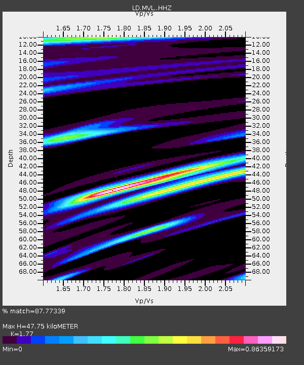
| Estimated Moho Depth: |
47.75 km |
| Estimated Crust Vp/Vs: |
1.77 |
| Assumed Crust Vp: |
6.419 km/s |
| Estimated Crust Vs: |
3.627 km/s |
| Estimated Crust Poisson's Ratio: |
0.27 |
|
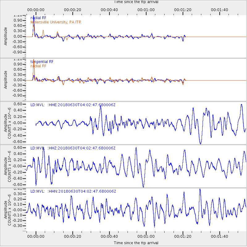
| Radial Match: |
87.77339 % |
| Radial Bump: |
400 |
| Transverse Match: |
70.37536 % |
| Transverse Bump: |
400 |
| SOD ConfigId: |
13570011 |
| Insert Time: |
2019-04-30 11:54:40.148 +0000 |
| GWidth: |
2.5 |
| Max Bumps: |
400 |
| Tol: |
0.001 |
|
Signal To Noise
| Channel | StoN | STA | LTA |
| LD:MVL: :HHZ:20180630T04:02:47.680006Z | 4.5566773 | 3.1772646E-7 | 6.972766E-8 |
| LD:MVL: :HHN:20180630T04:02:47.680006Z | 0.94336903 | 7.6273075E-8 | 8.085179E-8 |
| LD:MVL: :HHE:20180630T04:02:47.680006Z | 4.1923246 | 2.4325894E-7 | 5.8024835E-8 |
| Arrivals |
| Ps | 6.2 SECOND |
| PpPs | 19 SECOND |
| PsPs/PpSs | 25 SECOND |


