You are here: Home > Network List > TA - USArray Transportable Network (new EarthScope stations) Stations List
> Station B20K Meade River, AK, USA > Earthquake Result Viewer
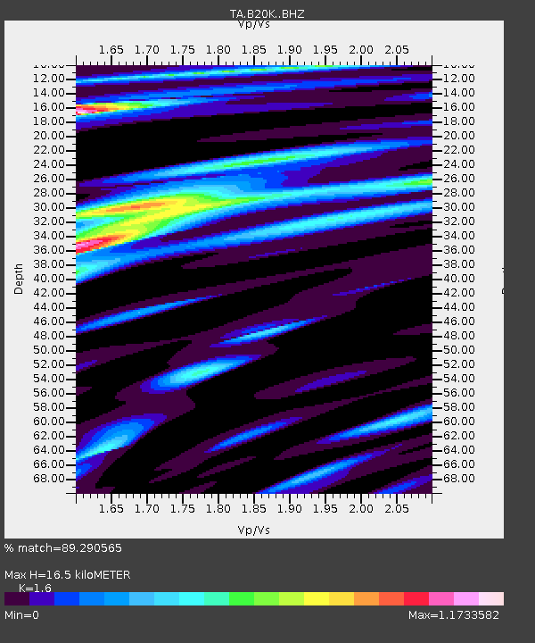
B20K Meade River, AK, USA - Earthquake Result Viewer
| Earthquake location: |
Near Coast Of Jalisco, Mexico |
| Earthquake latitude/longitude: |
19.1/-105.1 |
| Earthquake time(UTC): |
2018/06/30 (181) 03:56:50 GMT |
| Earthquake Depth: |
15 km |
| Earthquake Magnitude: |
5.9 Mww |
| Earthquake Catalog/Contributor: |
NEIC PDE/us |
|
| Network: |
TA USArray Transportable Network (new EarthScope stations) |
| Station: |
B20K Meade River, AK, USA |
| Lat/Lon: |
70.01 N/157.16 W |
| Elevation: |
75 m |
|
| Distance: |
59.7 deg |
| Az: |
341.689 deg |
| Baz: |
120.231 deg |
| Ray Param: |
0.062022384 |
| Estimated Moho Depth: |
16.5 km |
| Estimated Crust Vp/Vs: |
1.60 |
| Assumed Crust Vp: |
6.048 km/s |
| Estimated Crust Vs: |
3.78 km/s |
| Estimated Crust Poisson's Ratio: |
0.18 |
|
| Radial Match: |
89.290565 % |
| Radial Bump: |
400 |
| Transverse Match: |
81.637344 % |
| Transverse Bump: |
400 |
| SOD ConfigId: |
13570011 |
| Insert Time: |
2019-04-30 11:56:18.412 +0000 |
| GWidth: |
2.5 |
| Max Bumps: |
400 |
| Tol: |
0.001 |
|

Signal To Noise
| Channel | StoN | STA | LTA |
| TA:B20K: :BHZ:20180630T04:06:22.199995Z | 4.419953 | 6.200926E-7 | 1.4029393E-7 |
| TA:B20K: :BHN:20180630T04:06:22.199995Z | 2.0940669 | 1.4607511E-7 | 6.9756666E-8 |
| TA:B20K: :BHE:20180630T04:06:22.199995Z | 2.1779158 | 1.7695947E-7 | 8.125175E-8 |
| Arrivals |
| Ps | 1.7 SECOND |
| PpPs | 6.8 SECOND |
| PsPs/PpSs | 8.5 SECOND |


