You are here: Home > Network List > TA - USArray Transportable Network (new EarthScope stations) Stations List
> Station C16K Lisburne Hills, AK, USA > Earthquake Result Viewer
C16K Lisburne Hills, AK, USA - Earthquake Result Viewer
| Earthquake location: |
Near Coast Of Jalisco, Mexico |
| Earthquake latitude/longitude: |
19.1/-105.1 |
| Earthquake time(UTC): |
2018/06/30 (181) 03:56:50 GMT |
| Earthquake Depth: |
15 km |
| Earthquake Magnitude: |
5.9 Mww |
| Earthquake Catalog/Contributor: |
NEIC PDE/us |
|
| Network: |
TA USArray Transportable Network (new EarthScope stations) |
| Station: |
C16K Lisburne Hills, AK, USA |
| Lat/Lon: |
68.27 N/165.34 W |
| Elevation: |
102 m |
|
| Distance: |
61.6 deg |
| Az: |
338.438 deg |
| Baz: |
110.991 deg |
| Ray Param: |
0.060782976 |
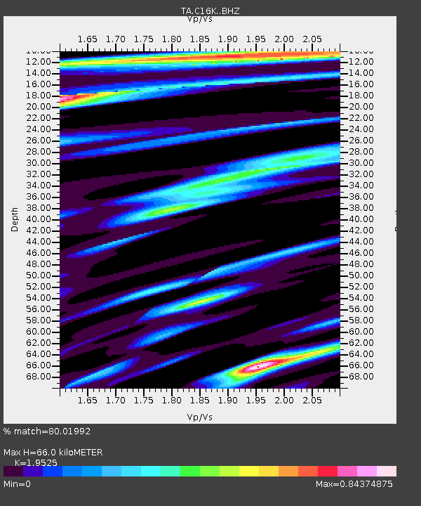
| Estimated Moho Depth: |
66.0 km |
| Estimated Crust Vp/Vs: |
1.95 |
| Assumed Crust Vp: |
5.906 km/s |
| Estimated Crust Vs: |
3.025 km/s |
| Estimated Crust Poisson's Ratio: |
0.32 |
|
| Radial Match: |
80.01992 % |
| Radial Bump: |
400 |
| Transverse Match: |
73.60875 % |
| Transverse Bump: |
400 |
| SOD ConfigId: |
13570011 |
| Insert Time: |
2019-04-30 11:56:20.994 +0000 |
| GWidth: |
2.5 |
| Max Bumps: |
400 |
| Tol: |
0.001 |
|
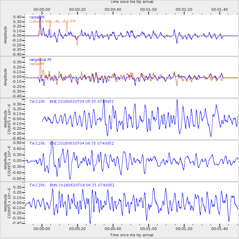
Signal To Noise
| Channel | StoN | STA | LTA |
| TA:C16K: :BHZ:20180630T04:06:35.074995Z | 4.8430357 | 3.2653898E-7 | 6.7424445E-8 |
| TA:C16K: :BHN:20180630T04:06:35.074995Z | 1.1542431 | 6.5182256E-8 | 5.6471865E-8 |
| TA:C16K: :BHE:20180630T04:06:35.074995Z | 1.8943119 | 1.4990879E-7 | 7.913628E-8 |
| Arrivals |
| Ps | 11 SECOND |
| PpPs | 32 SECOND |
| PsPs/PpSs | 43 SECOND |


