You are here: Home > Network List > US - United States National Seismic Network Stations List
> Station AMTX Amarillo, Texas, USA > Earthquake Result Viewer
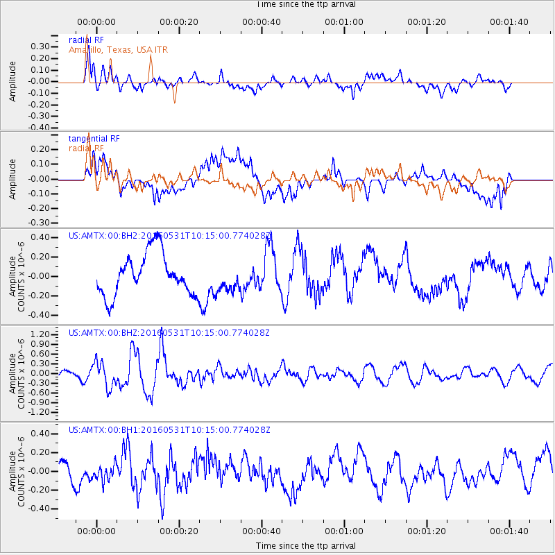
AMTX Amarillo, Texas, USA - Earthquake Result Viewer
*The percent match for this event was below the threshold and hence no stack was calculated.
| Earthquake location: |
Kuril Islands |
| Earthquake latitude/longitude: |
47.5/154.4 |
| Earthquake time(UTC): |
2016/05/31 (152) 10:03:59 GMT |
| Earthquake Depth: |
10 km |
| Earthquake Magnitude: |
5.5 MB |
| Earthquake Catalog/Contributor: |
NEIC PDE/NEIC COMCAT |
|
| Network: |
US United States National Seismic Network |
| Station: |
AMTX Amarillo, Texas, USA |
| Lat/Lon: |
34.53 N/101.41 W |
| Elevation: |
1010 m |
|
| Distance: |
73.9 deg |
| Az: |
56.41 deg |
| Baz: |
316.882 deg |
| Ray Param: |
$rayparam |
*The percent match for this event was below the threshold and hence was not used in the summary stack. |
|
| Radial Match: |
52.66274 % |
| Radial Bump: |
400 |
| Transverse Match: |
48.268158 % |
| Transverse Bump: |
400 |
| SOD ConfigId: |
1475611 |
| Insert Time: |
2016-06-14 10:12:50.385 +0000 |
| GWidth: |
2.5 |
| Max Bumps: |
400 |
| Tol: |
0.001 |
|
Signal To Noise
| Channel | StoN | STA | LTA |
| US:AMTX:00:BHZ:20160531T10:15:00.774028Z | 4.368356 | 3.9825636E-7 | 9.1168474E-8 |
| US:AMTX:00:BH1:20160531T10:15:00.774028Z | 0.6909987 | 7.983149E-8 | 1.155306E-7 |
| US:AMTX:00:BH2:20160531T10:15:00.774028Z | 0.56385875 | 1.3033518E-7 | 2.3114865E-7 |
| Arrivals |
| Ps | |
| PpPs | |
| PsPs/PpSs | |


