You are here: Home > Network List > TA - USArray Transportable Network (new EarthScope stations) Stations List
> Station G16K Koyuk River, AK, USA > Earthquake Result Viewer
G16K Koyuk River, AK, USA - Earthquake Result Viewer
| Earthquake location: |
Near Coast Of Jalisco, Mexico |
| Earthquake latitude/longitude: |
19.1/-105.1 |
| Earthquake time(UTC): |
2018/06/30 (181) 03:56:50 GMT |
| Earthquake Depth: |
15 km |
| Earthquake Magnitude: |
5.9 Mww |
| Earthquake Catalog/Contributor: |
NEIC PDE/us |
|
| Network: |
TA USArray Transportable Network (new EarthScope stations) |
| Station: |
G16K Koyuk River, AK, USA |
| Lat/Lon: |
65.39 N/162.35 W |
| Elevation: |
169 m |
|
| Distance: |
59.4 deg |
| Az: |
335.852 deg |
| Baz: |
112.463 deg |
| Ray Param: |
0.06220651 |
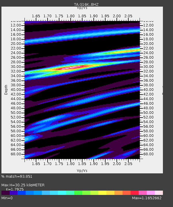
| Estimated Moho Depth: |
30.25 km |
| Estimated Crust Vp/Vs: |
1.79 |
| Assumed Crust Vp: |
6.276 km/s |
| Estimated Crust Vs: |
3.501 km/s |
| Estimated Crust Poisson's Ratio: |
0.27 |
|
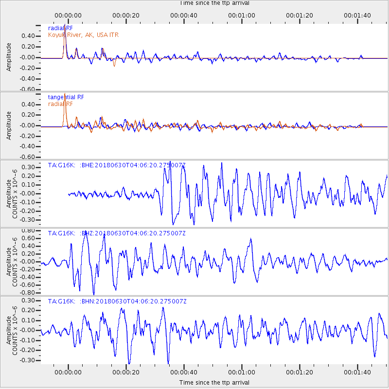
| Radial Match: |
93.851 % |
| Radial Bump: |
400 |
| Transverse Match: |
80.22453 % |
| Transverse Bump: |
400 |
| SOD ConfigId: |
13570011 |
| Insert Time: |
2019-04-30 11:56:59.642 +0000 |
| GWidth: |
2.5 |
| Max Bumps: |
400 |
| Tol: |
0.001 |
|
Signal To Noise
| Channel | StoN | STA | LTA |
| TA:G16K: :BHZ:20180630T04:06:20.275007Z | 7.28211 | 3.4816853E-7 | 4.781149E-8 |
| TA:G16K: :BHN:20180630T04:06:20.275007Z | 2.308999 | 7.579757E-8 | 3.2827028E-8 |
| TA:G16K: :BHE:20180630T04:06:20.275007Z | 7.584773 | 1.8705087E-7 | 2.4661368E-8 |
| Arrivals |
| Ps | 4.0 SECOND |
| PpPs | 13 SECOND |
| PsPs/PpSs | 17 SECOND |


