You are here: Home > Network List > TA - USArray Transportable Network (new EarthScope stations) Stations List
> Station G25K Bearman Lake, AK, USA > Earthquake Result Viewer
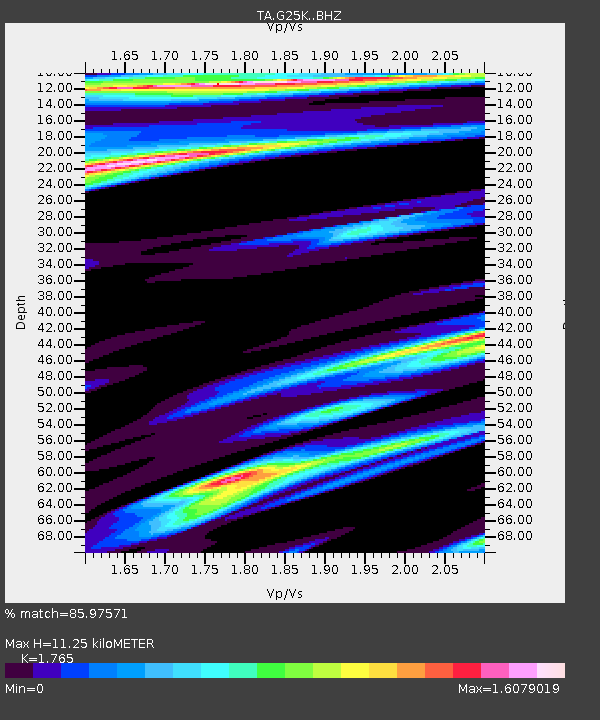
G25K Bearman Lake, AK, USA - Earthquake Result Viewer
| Earthquake location: |
Near Coast Of Jalisco, Mexico |
| Earthquake latitude/longitude: |
19.1/-105.1 |
| Earthquake time(UTC): |
2018/06/30 (181) 03:56:50 GMT |
| Earthquake Depth: |
15 km |
| Earthquake Magnitude: |
5.9 Mww |
| Earthquake Catalog/Contributor: |
NEIC PDE/us |
|
| Network: |
TA USArray Transportable Network (new EarthScope stations) |
| Station: |
G25K Bearman Lake, AK, USA |
| Lat/Lon: |
66.77 N/146.10 W |
| Elevation: |
146 m |
|
| Distance: |
54.5 deg |
| Az: |
341.35 deg |
| Baz: |
130.326 deg |
| Ray Param: |
0.06542363 |
| Estimated Moho Depth: |
11.25 km |
| Estimated Crust Vp/Vs: |
1.76 |
| Assumed Crust Vp: |
6.522 km/s |
| Estimated Crust Vs: |
3.695 km/s |
| Estimated Crust Poisson's Ratio: |
0.26 |
|
| Radial Match: |
85.97571 % |
| Radial Bump: |
325 |
| Transverse Match: |
71.86499 % |
| Transverse Bump: |
400 |
| SOD ConfigId: |
13570011 |
| Insert Time: |
2019-04-30 11:57:06.259 +0000 |
| GWidth: |
2.5 |
| Max Bumps: |
400 |
| Tol: |
0.001 |
|

Signal To Noise
| Channel | StoN | STA | LTA |
| TA:G25K: :BHZ:20180630T04:05:45.400007Z | 8.780366 | 9.710051E-7 | 1.1058823E-7 |
| TA:G25K: :BHN:20180630T04:05:45.400007Z | 1.3862559 | 3.832244E-7 | 2.7644566E-7 |
| TA:G25K: :BHE:20180630T04:05:45.400007Z | 1.7182336 | 3.200437E-7 | 1.8626321E-7 |
| Arrivals |
| Ps | 1.4 SECOND |
| PpPs | 4.5 SECOND |
| PsPs/PpSs | 5.9 SECOND |


