You are here: Home > Network List > TA - USArray Transportable Network (new EarthScope stations) Stations List
> Station G26K Porcupine River, AK, USA > Earthquake Result Viewer
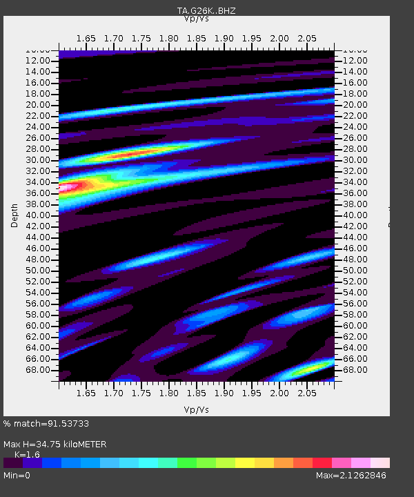
G26K Porcupine River, AK, USA - Earthquake Result Viewer
| Earthquake location: |
Near Coast Of Jalisco, Mexico |
| Earthquake latitude/longitude: |
19.1/-105.1 |
| Earthquake time(UTC): |
2018/06/30 (181) 03:56:50 GMT |
| Earthquake Depth: |
15 km |
| Earthquake Magnitude: |
5.9 Mww |
| Earthquake Catalog/Contributor: |
NEIC PDE/us |
|
| Network: |
TA USArray Transportable Network (new EarthScope stations) |
| Station: |
G26K Porcupine River, AK, USA |
| Lat/Lon: |
66.95 N/143.78 W |
| Elevation: |
180 m |
|
| Distance: |
53.9 deg |
| Az: |
342.271 deg |
| Baz: |
132.993 deg |
| Ray Param: |
0.065779336 |
| Estimated Moho Depth: |
34.75 km |
| Estimated Crust Vp/Vs: |
1.60 |
| Assumed Crust Vp: |
6.577 km/s |
| Estimated Crust Vs: |
4.11 km/s |
| Estimated Crust Poisson's Ratio: |
0.18 |
|
| Radial Match: |
91.53733 % |
| Radial Bump: |
400 |
| Transverse Match: |
85.21423 % |
| Transverse Bump: |
400 |
| SOD ConfigId: |
13570011 |
| Insert Time: |
2019-04-30 11:57:07.936 +0000 |
| GWidth: |
2.5 |
| Max Bumps: |
400 |
| Tol: |
0.001 |
|

Signal To Noise
| Channel | StoN | STA | LTA |
| TA:G26K: :BHZ:20180630T04:05:41.324995Z | 7.0719275 | 3.7853496E-7 | 5.3526424E-8 |
| TA:G26K: :BHN:20180630T04:05:41.324995Z | 4.93438 | 2.0814439E-7 | 4.2182478E-8 |
| TA:G26K: :BHE:20180630T04:05:41.324995Z | 5.2871776 | 2.4709104E-7 | 4.6734016E-8 |
| Arrivals |
| Ps | 3.4 SECOND |
| PpPs | 13 SECOND |
| PsPs/PpSs | 16 SECOND |


