You are here: Home > Network List > TA - USArray Transportable Network (new EarthScope stations) Stations List
> Station J25K Salcha River, AK, USA > Earthquake Result Viewer
J25K Salcha River, AK, USA - Earthquake Result Viewer
| Earthquake location: |
Near Coast Of Jalisco, Mexico |
| Earthquake latitude/longitude: |
19.1/-105.1 |
| Earthquake time(UTC): |
2018/06/30 (181) 03:56:50 GMT |
| Earthquake Depth: |
15 km |
| Earthquake Magnitude: |
5.9 Mww |
| Earthquake Catalog/Contributor: |
NEIC PDE/us |
|
| Network: |
TA USArray Transportable Network (new EarthScope stations) |
| Station: |
J25K Salcha River, AK, USA |
| Lat/Lon: |
64.61 N/145.37 W |
| Elevation: |
949 m |
|
| Distance: |
52.8 deg |
| Az: |
339.54 deg |
| Baz: |
129.919 deg |
| Ray Param: |
0.06649266 |
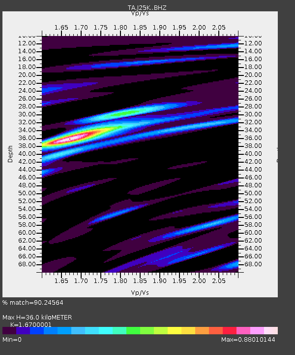
| Estimated Moho Depth: |
36.0 km |
| Estimated Crust Vp/Vs: |
1.67 |
| Assumed Crust Vp: |
6.566 km/s |
| Estimated Crust Vs: |
3.932 km/s |
| Estimated Crust Poisson's Ratio: |
0.22 |
|
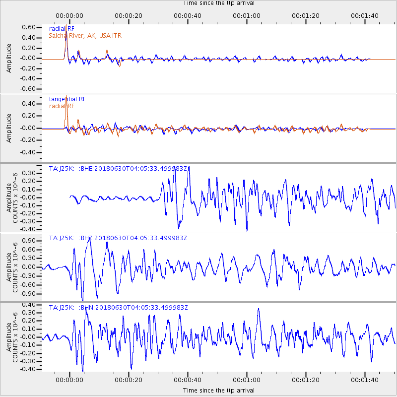
| Radial Match: |
90.24564 % |
| Radial Bump: |
380 |
| Transverse Match: |
79.33451 % |
| Transverse Bump: |
400 |
| SOD ConfigId: |
13570011 |
| Insert Time: |
2019-04-30 11:57:37.848 +0000 |
| GWidth: |
2.5 |
| Max Bumps: |
400 |
| Tol: |
0.001 |
|
Signal To Noise
| Channel | StoN | STA | LTA |
| TA:J25K: :BHZ:20180630T04:05:33.499983Z | 11.078585 | 4.9026767E-7 | 4.425364E-8 |
| TA:J25K: :BHN:20180630T04:05:33.499983Z | 7.268896 | 1.8250515E-7 | 2.5107683E-8 |
| TA:J25K: :BHE:20180630T04:05:33.499983Z | 8.137391 | 1.7648314E-7 | 2.1687928E-8 |
| Arrivals |
| Ps | 3.9 SECOND |
| PpPs | 14 SECOND |
| PsPs/PpSs | 18 SECOND |


