You are here: Home > Network List > TA - USArray Transportable Network (new EarthScope stations) Stations List
> Station L14K Kuka Creek, AK, USA > Earthquake Result Viewer
L14K Kuka Creek, AK, USA - Earthquake Result Viewer
| Earthquake location: |
Near Coast Of Jalisco, Mexico |
| Earthquake latitude/longitude: |
19.1/-105.1 |
| Earthquake time(UTC): |
2018/06/30 (181) 03:56:50 GMT |
| Earthquake Depth: |
15 km |
| Earthquake Magnitude: |
5.9 Mww |
| Earthquake Catalog/Contributor: |
NEIC PDE/us |
|
| Network: |
TA USArray Transportable Network (new EarthScope stations) |
| Station: |
L14K Kuka Creek, AK, USA |
| Lat/Lon: |
61.34 N/162.68 W |
| Elevation: |
41 m |
|
| Distance: |
58.1 deg |
| Az: |
331.35 deg |
| Baz: |
109.832 deg |
| Ray Param: |
0.06307752 |
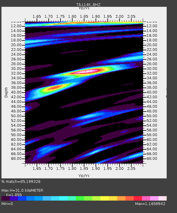
| Estimated Moho Depth: |
31.0 km |
| Estimated Crust Vp/Vs: |
1.86 |
| Assumed Crust Vp: |
6.1 km/s |
| Estimated Crust Vs: |
3.288 km/s |
| Estimated Crust Poisson's Ratio: |
0.30 |
|
| Radial Match: |
85.199326 % |
| Radial Bump: |
400 |
| Transverse Match: |
75.20413 % |
| Transverse Bump: |
400 |
| SOD ConfigId: |
13570011 |
| Insert Time: |
2019-04-30 11:57:51.061 +0000 |
| GWidth: |
2.5 |
| Max Bumps: |
400 |
| Tol: |
0.001 |
|

Signal To Noise
| Channel | StoN | STA | LTA |
| TA:L14K: :BHZ:20180630T04:06:11.025007Z | 4.341512 | 3.8580507E-7 | 8.886421E-8 |
| TA:L14K: :BHN:20180630T04:06:11.025007Z | 2.1331515 | 1.13476844E-7 | 5.3196803E-8 |
| TA:L14K: :BHE:20180630T04:06:11.025007Z | 3.4111762 | 1.8874722E-7 | 5.5332006E-8 |
| Arrivals |
| Ps | 4.5 SECOND |
| PpPs | 14 SECOND |
| PsPs/PpSs | 18 SECOND |


