You are here: Home > Network List > TA - USArray Transportable Network (new EarthScope stations) Stations List
> Station 114A Black Gap (USAF), Gila Bend, AZ, USA > Earthquake Result Viewer
114A Black Gap (USAF), Gila Bend, AZ, USA - Earthquake Result Viewer
| Earthquake location: |
Kermadec Islands, New Zealand |
| Earthquake latitude/longitude: |
-29.8/-177.7 |
| Earthquake time(UTC): |
2008/09/29 (273) 15:19:31 GMT |
| Earthquake Depth: |
36 km |
| Earthquake Magnitude: |
6.5 MB, 6.7 MS, 7.0 MW, 7.0 MW |
| Earthquake Catalog/Contributor: |
WHDF/NEIC |
|
| Network: |
TA USArray Transportable Network (new EarthScope stations) |
| Station: |
114A Black Gap (USAF), Gila Bend, AZ, USA |
| Lat/Lon: |
32.75 N/112.88 W |
| Elevation: |
279 m |
|
| Distance: |
87.4 deg |
| Az: |
49.755 deg |
| Baz: |
231.967 deg |
| Ray Param: |
0.043335944 |
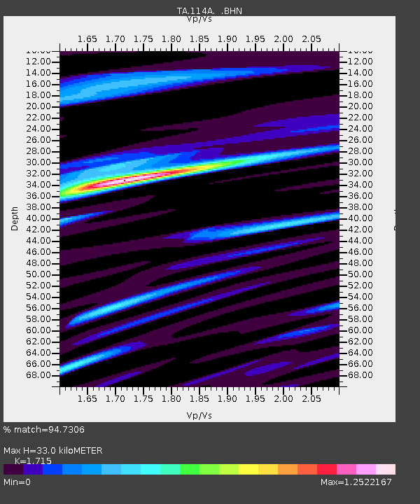
| Estimated Moho Depth: |
33.0 km |
| Estimated Crust Vp/Vs: |
1.72 |
| Assumed Crust Vp: |
6.264 km/s |
| Estimated Crust Vs: |
3.652 km/s |
| Estimated Crust Poisson's Ratio: |
0.24 |
|
| Radial Match: |
94.7306 % |
| Radial Bump: |
400 |
| Transverse Match: |
92.179985 % |
| Transverse Bump: |
400 |
| SOD ConfigId: |
2560 |
| Insert Time: |
2010-03-06 12:14:46.234 +0000 |
| GWidth: |
2.5 |
| Max Bumps: |
400 |
| Tol: |
0.001 |
|

Signal To Noise
| Channel | StoN | STA | LTA |
| TA:114A: :BHN:20080929T15:31:43.649021Z | 7.1001062 | 5.961149E-7 | 8.395858E-8 |
| TA:114A: :BHE:20080929T15:31:43.649021Z | 3.5995994 | 2.1508338E-7 | 5.975203E-8 |
| TA:114A: :BHZ:20080929T15:31:43.649021Z | 1.7156702 | 1.3950759E-7 | 8.131376E-8 |
| Arrivals |
| Ps | 3.9 SECOND |
| PpPs | 14 SECOND |
| PsPs/PpSs | 18 SECOND |


