You are here: Home > Network List > TA - USArray Transportable Network (new EarthScope stations) Stations List
> Station 114A Black Gap (USAF), Gila Bend, AZ, USA > Earthquake Result Viewer
114A Black Gap (USAF), Gila Bend, AZ, USA - Earthquake Result Viewer
| Earthquake location: |
Panama-Costa Rica Border Region |
| Earthquake latitude/longitude: |
8.3/-83.0 |
| Earthquake time(UTC): |
2008/11/19 (324) 06:11:20 GMT |
| Earthquake Depth: |
32 km |
| Earthquake Magnitude: |
5.9 MB, 5.9 MS, 6.2 MW, 6.1 MW |
| Earthquake Catalog/Contributor: |
WHDF/NEIC |
|
| Network: |
TA USArray Transportable Network (new EarthScope stations) |
| Station: |
114A Black Gap (USAF), Gila Bend, AZ, USA |
| Lat/Lon: |
32.75 N/112.88 W |
| Elevation: |
279 m |
|
| Distance: |
36.9 deg |
| Az: |
315.561 deg |
| Baz: |
124.679 deg |
| Ray Param: |
0.076377414 |
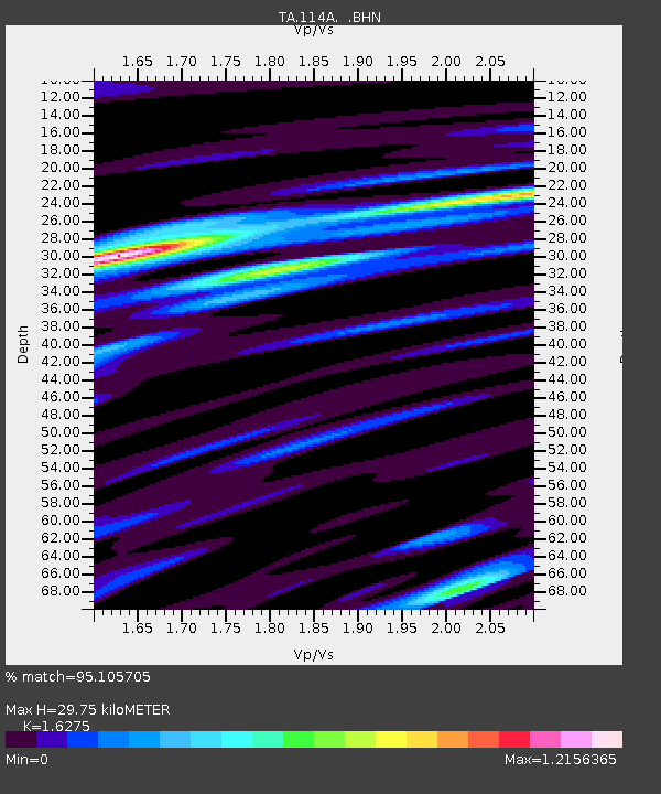
| Estimated Moho Depth: |
29.75 km |
| Estimated Crust Vp/Vs: |
1.63 |
| Assumed Crust Vp: |
6.264 km/s |
| Estimated Crust Vs: |
3.849 km/s |
| Estimated Crust Poisson's Ratio: |
0.20 |
|
| Radial Match: |
95.105705 % |
| Radial Bump: |
380 |
| Transverse Match: |
90.18695 % |
| Transverse Bump: |
400 |
| SOD ConfigId: |
2658 |
| Insert Time: |
2010-03-06 12:14:56.186 +0000 |
| GWidth: |
2.5 |
| Max Bumps: |
400 |
| Tol: |
0.001 |
|

Signal To Noise
| Channel | StoN | STA | LTA |
| TA:114A: :BHN:20081119T06:17:55.92501Z | 12.230204 | 1.000737E-6 | 8.182505E-8 |
| TA:114A: :BHE:20081119T06:17:55.92501Z | 1.6314182 | 1.8432242E-7 | 1.1298294E-7 |
| TA:114A: :BHZ:20081119T06:17:55.92501Z | 2.232868 | 2.7460496E-7 | 1.2298307E-7 |
| Arrivals |
| Ps | 3.2 SECOND |
| PpPs | 12 SECOND |
| PsPs/PpSs | 15 SECOND |


