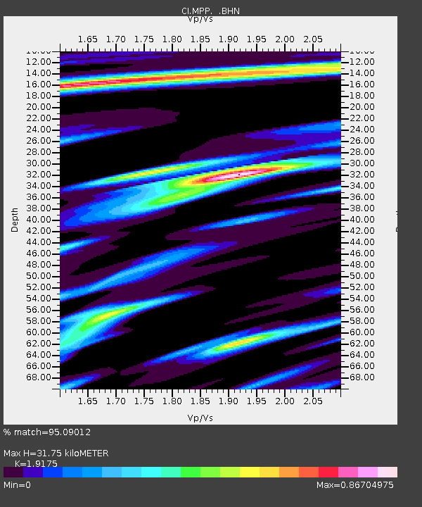
MPP McPhearson Peak - Earthquake Result Viewer
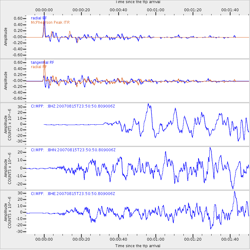
Earthquake location: Near Coast Of Peru
Earthquake latitude/longitude: -13.4/-76.6
Earthquake time(UTC): 2007/08/15 (227) 23:40:57 GMT
Earthquake Depth: 39 km
Earthquake Magnitude: 6.7 MB, 7.9 MS, 8.0 MW, 7.5 ME
Earthquake Catalog/Contributor: WHDF/NEIC
Network: CI Caltech Regional Seismic Network
Station: MPP McPhearson Peak
Lat/Lon: 34.89 N/119.81 W
Elevation: 1739 m
Distance: 63.1 deg
Az: 320.874 deg
Baz: 131.667 deg
Ray Param: 0.059710264
Estimated Moho Depth: 31.75 km
Estimated Crust Vp/Vs: 1.92
Assumed Crust Vp: 6.1 km/s
Estimated Crust Vs: 3.181 km/s
Estimated Crust Poisson's Ratio: 0.31
Radial Match: 95.09012 %
Radial Bump: 310
Transverse Match: 84.1 %
Transverse Bump: 400
SOD ConfigId: 2564
Insert Time: 2010-02-26 02:02:54.030 +0000
GWidth: 2.5
Max Bumps: 400
Tol: 0.001

Signal To Noise

ChannelStoNSTALTA
CI:MPP: :BHN:20070815T23:50:50.809006Z2.3924915.5195704E-72.307039E-7
CI:MPP: :BHE:20070815T23:50:50.809006Z4.00720938.46931E-72.1135185E-7
CI:MPP: :BHZ:20070815T23:50:50.809006Z8.5685491.804245E-62.1056599E-7
Arrivals
Ps5.0 SECOND
PpPs15 SECOND
PsPs/PpSs20 SECOND