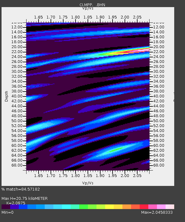
MPP McPhearson Peak - Earthquake Result Viewer
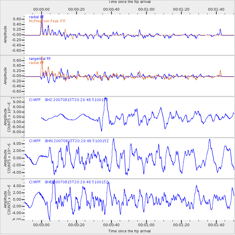
Earthquake location: Andreanof Islands, Aleutian Is.
Earthquake latitude/longitude: 50.3/-177.5
Earthquake time(UTC): 2007/08/15 (227) 20:22:11 GMT
Earthquake Depth: 9.0 km
Earthquake Magnitude: 6.3 MB, 6.2 MS, 6.4 MW, 5.9 ML
Earthquake Catalog/Contributor: WHDF/NEIC
Network: CI Caltech Regional Seismic Network
Station: MPP McPhearson Peak
Lat/Lon: 34.89 N/119.81 W
Elevation: 1739 m
Distance: 44.1 deg
Az: 87.681 deg
Baz: 308.82 deg
Ray Param: 0.07213799
Estimated Moho Depth: 20.75 km
Estimated Crust Vp/Vs: 2.10
Assumed Crust Vp: 6.1 km/s
Estimated Crust Vs: 2.908 km/s
Estimated Crust Poisson's Ratio: 0.35
Radial Match: 84.57182 %
Radial Bump: 385
Transverse Match: 73.6836 %
Transverse Bump: 400
SOD ConfigId: 2564
Insert Time: 2010-02-26 02:02:55.476 +0000
GWidth: 2.5
Max Bumps: 400
Tol: 0.001

Signal To Noise

ChannelStoNSTALTA
CI:MPP: :BHN:20070815T20:29:48.510015Z1.50798251.0702495E-67.097227E-7
CI:MPP: :BHE:20070815T20:29:48.510015Z1.85014982.4386832E-61.3181003E-6
CI:MPP: :BHZ:20070815T20:29:48.510015Z2.62931063.1725028E-61.2065912E-6
Arrivals
Ps3.9 SECOND
PpPs10 SECOND
PsPs/PpSs14 SECOND