You are here: Home > Network List > TA - USArray Transportable Network (new EarthScope stations) Stations List
> Station 114A Black Gap (USAF), Gila Bend, AZ, USA > Earthquake Result Viewer
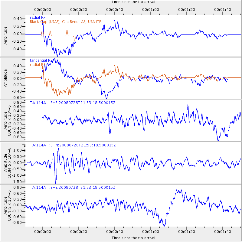
114A Black Gap (USAF), Gila Bend, AZ, USA - Earthquake Result Viewer
*The percent match for this event was below the threshold and hence no stack was calculated.
| Earthquake location: |
Solomon Islands |
| Earthquake latitude/longitude: |
-10.6/163.1 |
| Earthquake time(UTC): |
2008/07/28 (210) 21:40:47 GMT |
| Earthquake Depth: |
10 km |
| Earthquake Magnitude: |
5.9 MB, 5.8 MS, 6.0 MW |
| Earthquake Catalog/Contributor: |
WHDF/NEIC |
|
| Network: |
TA USArray Transportable Network (new EarthScope stations) |
| Station: |
114A Black Gap (USAF), Gila Bend, AZ, USA |
| Lat/Lon: |
32.75 N/112.88 W |
| Elevation: |
279 m |
|
| Distance: |
90.7 deg |
| Az: |
56.944 deg |
| Baz: |
257.941 deg |
| Ray Param: |
$rayparam |
*The percent match for this event was below the threshold and hence was not used in the summary stack. |
|
| Radial Match: |
51.900173 % |
| Radial Bump: |
400 |
| Transverse Match: |
46.5971 % |
| Transverse Bump: |
400 |
| SOD ConfigId: |
2504 |
| Insert Time: |
2010-03-06 12:17:04.463 +0000 |
| GWidth: |
2.5 |
| Max Bumps: |
400 |
| Tol: |
0.001 |
|
Signal To Noise
| Channel | StoN | STA | LTA |
| TA:114A: :BHN:20080728T21:53:18.500015Z | 1.9522617 | 1.7230592E-7 | 8.825964E-8 |
| TA:114A: :BHE:20080728T21:53:18.500015Z | 1.7689762 | 2.0786483E-7 | 1.1750572E-7 |
| TA:114A: :BHZ:20080728T21:53:18.500015Z | 0.55641395 | 6.0853885E-8 | 1.0936801E-7 |
| Arrivals |
| Ps | |
| PpPs | |
| PsPs/PpSs | |


