You are here: Home > Network List > TA - USArray Transportable Network (new EarthScope stations) Stations List
> Station 114A Black Gap (USAF), Gila Bend, AZ, USA > Earthquake Result Viewer
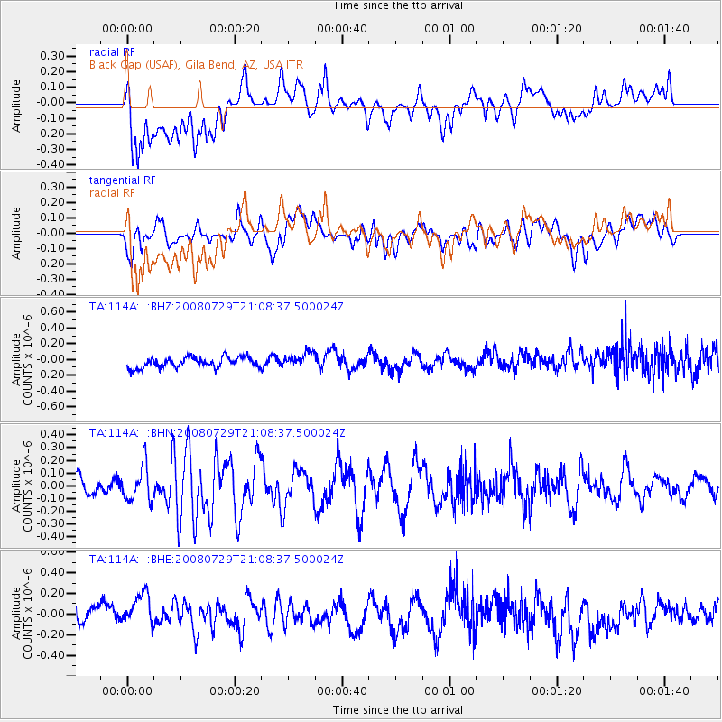
114A Black Gap (USAF), Gila Bend, AZ, USA - Earthquake Result Viewer
*The percent match for this event was below the threshold and hence no stack was calculated.
| Earthquake location: |
Southern East Pacific Rise |
| Earthquake latitude/longitude: |
-54.7/-118.8 |
| Earthquake time(UTC): |
2008/07/29 (211) 20:56:22 GMT |
| Earthquake Depth: |
10 km |
| Earthquake Magnitude: |
5.5 MB, 5.4 MS, 5.8 MW, 5.7 MW |
| Earthquake Catalog/Contributor: |
WHDF/NEIC |
|
| Network: |
TA USArray Transportable Network (new EarthScope stations) |
| Station: |
114A Black Gap (USAF), Gila Bend, AZ, USA |
| Lat/Lon: |
32.75 N/112.88 W |
| Elevation: |
279 m |
|
| Distance: |
87.3 deg |
| Az: |
4.975 deg |
| Baz: |
183.422 deg |
| Ray Param: |
$rayparam |
*The percent match for this event was below the threshold and hence was not used in the summary stack. |
|
| Radial Match: |
58.426674 % |
| Radial Bump: |
400 |
| Transverse Match: |
63.15173 % |
| Transverse Bump: |
400 |
| SOD ConfigId: |
2504 |
| Insert Time: |
2010-03-06 12:17:05.180 +0000 |
| GWidth: |
2.5 |
| Max Bumps: |
400 |
| Tol: |
0.001 |
|
Signal To Noise
| Channel | StoN | STA | LTA |
| TA:114A: :BHN:20080729T21:08:37.500024Z | 1.7434654 | 1.4054953E-7 | 8.061504E-8 |
| TA:114A: :BHE:20080729T21:08:37.500024Z | 1.5471184 | 2.0431189E-7 | 1.3205963E-7 |
| TA:114A: :BHZ:20080729T21:08:37.500024Z | 1.4483234 | 9.616326E-8 | 6.639627E-8 |
| Arrivals |
| Ps | |
| PpPs | |
| PsPs/PpSs | |


