You are here: Home > Network List > TA - USArray Transportable Network (new EarthScope stations) Stations List
> Station 114A Black Gap (USAF), Gila Bend, AZ, USA > Earthquake Result Viewer
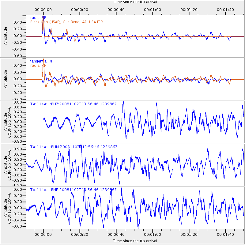
114A Black Gap (USAF), Gila Bend, AZ, USA - Earthquake Result Viewer
*The percent match for this event was below the threshold and hence no stack was calculated.
| Earthquake location: |
Andreanof Islands, Aleutian Is. |
| Earthquake latitude/longitude: |
51.6/-174.4 |
| Earthquake time(UTC): |
2008/11/02 (307) 13:48:42 GMT |
| Earthquake Depth: |
36 km |
| Earthquake Magnitude: |
5.7 MB, 5.8 MS, 6.1 MW, 6.1 MW |
| Earthquake Catalog/Contributor: |
WHDF/NEIC |
|
| Network: |
TA USArray Transportable Network (new EarthScope stations) |
| Station: |
114A Black Gap (USAF), Gila Bend, AZ, USA |
| Lat/Lon: |
32.75 N/112.88 W |
| Elevation: |
279 m |
|
| Distance: |
47.8 deg |
| Az: |
88.305 deg |
| Baz: |
312.217 deg |
| Ray Param: |
$rayparam |
*The percent match for this event was below the threshold and hence was not used in the summary stack. |
|
| Radial Match: |
69.27819 % |
| Radial Bump: |
400 |
| Transverse Match: |
61.866634 % |
| Transverse Bump: |
400 |
| SOD ConfigId: |
2658 |
| Insert Time: |
2010-03-06 12:17:05.986 +0000 |
| GWidth: |
2.5 |
| Max Bumps: |
400 |
| Tol: |
0.001 |
|
Signal To Noise
| Channel | StoN | STA | LTA |
| TA:114A: :BHN:20081102T13:56:46.123986Z | 4.871145 | 3.2814023E-7 | 6.736409E-8 |
| TA:114A: :BHE:20081102T13:56:46.123986Z | 1.2247602 | 1.3593116E-7 | 1.1098594E-7 |
| TA:114A: :BHZ:20081102T13:56:46.123986Z | 0.8842947 | 1.5905422E-7 | 1.7986564E-7 |
| Arrivals |
| Ps | |
| PpPs | |
| PsPs/PpSs | |


