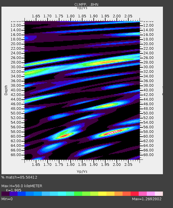
MPP McPhearson Peak - Earthquake Result Viewer
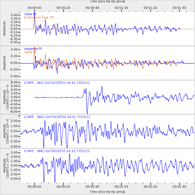
Earthquake location: Solomon Islands
Earthquake latitude/longitude: -8.0/154.6
Earthquake time(UTC): 2007/06/28 (179) 02:52:09 GMT
Earthquake Depth: 10 km
Earthquake Magnitude: 6.3 MB, 6.7 MS, 6.7 MW, 6.7 MW
Earthquake Catalog/Contributor: WHDF/NEIC
Network: CI Caltech Regional Seismic Network
Station: MPP McPhearson Peak
Lat/Lon: 34.89 N/119.81 W
Elevation: 1739 m
Distance: 90.9 deg
Az: 55.054 deg
Baz: 260.971 deg
Ray Param: 0.04164194
Estimated Moho Depth: 58.0 km
Estimated Crust Vp/Vs: 1.99
Assumed Crust Vp: 6.1 km/s
Estimated Crust Vs: 3.073 km/s
Estimated Crust Poisson's Ratio: 0.33
Radial Match: 85.58412 %
Radial Bump: 400
Transverse Match: 86.57225 %
Transverse Bump: 400
SOD ConfigId: 2564
Insert Time: 2010-02-26 02:02:59.686 +0000
GWidth: 2.5
Max Bumps: 400
Tol: 0.001

Signal To Noise

ChannelStoNSTALTA
CI:MPP: :BHN:20070628T03:04:41.735022Z1.77676094.2696564E-72.403056E-7
CI:MPP: :BHE:20070628T03:04:41.735022Z2.13232185.5561844E-72.605697E-7
CI:MPP: :BHZ:20070628T03:04:41.735022Z13.1137311.5088459E-61.1505847E-7
Arrivals
Ps9.5 SECOND
PpPs28 SECOND
PsPs/PpSs37 SECOND