You are here: Home > Network List > TA - USArray Transportable Network (new EarthScope stations) Stations List
> Station 628A Black Gap, Marathon, TX, USA > Earthquake Result Viewer
628A Black Gap, Marathon, TX, USA - Earthquake Result Viewer
| Earthquake location: |
Tonga Islands |
| Earthquake latitude/longitude: |
-15.1/-173.5 |
| Earthquake time(UTC): |
2008/08/19 (232) 16:30:13 GMT |
| Earthquake Depth: |
8.0 km |
| Earthquake Magnitude: |
5.6 MB, 5.9 MS, 6.1 MW, 6.0 MW |
| Earthquake Catalog/Contributor: |
WHDF/NEIC |
|
| Network: |
TA USArray Transportable Network (new EarthScope stations) |
| Station: |
628A Black Gap, Marathon, TX, USA |
| Lat/Lon: |
29.49 N/102.89 W |
| Elevation: |
655 m |
|
| Distance: |
81.2 deg |
| Az: |
56.32 deg |
| Baz: |
247.212 deg |
| Ray Param: |
0.047768507 |
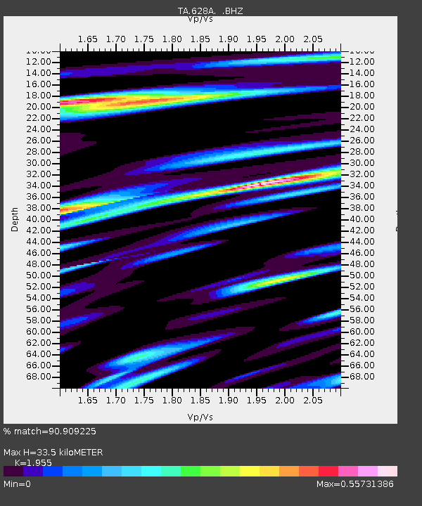
| Estimated Moho Depth: |
33.5 km |
| Estimated Crust Vp/Vs: |
1.96 |
| Assumed Crust Vp: |
6.419 km/s |
| Estimated Crust Vs: |
3.283 km/s |
| Estimated Crust Poisson's Ratio: |
0.32 |
|
| Radial Match: |
90.909225 % |
| Radial Bump: |
400 |
| Transverse Match: |
79.81971 % |
| Transverse Bump: |
381 |
| SOD ConfigId: |
2504 |
| Insert Time: |
2010-03-06 12:17:44.993 +0000 |
| GWidth: |
2.5 |
| Max Bumps: |
400 |
| Tol: |
0.001 |
|
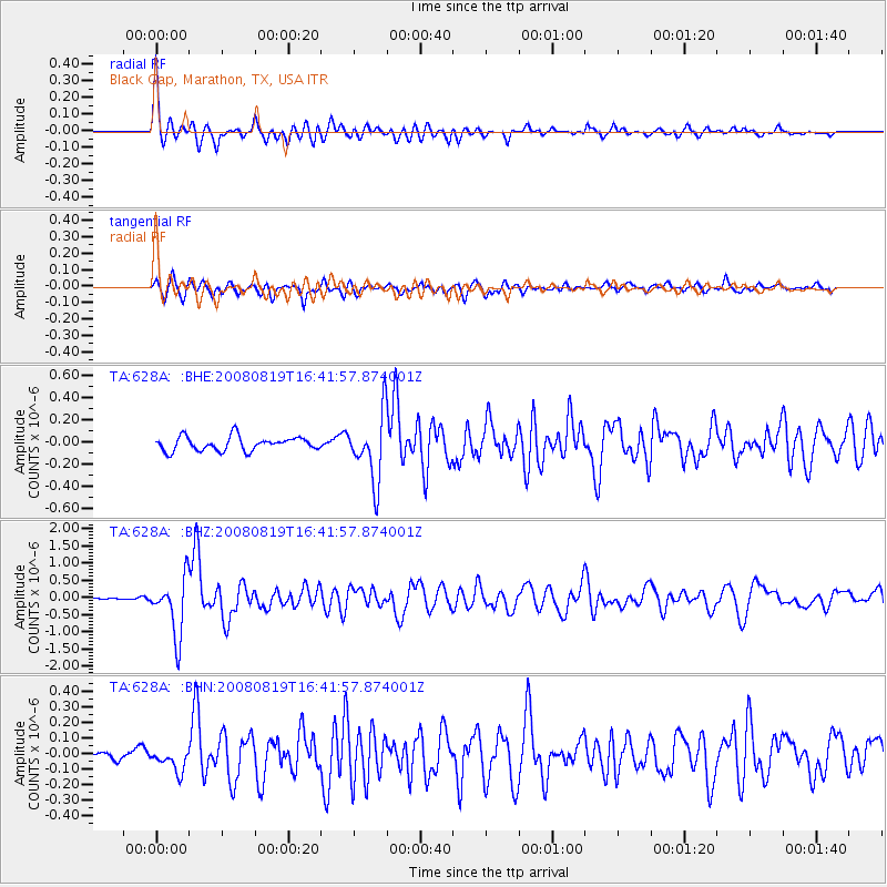
Signal To Noise
| Channel | StoN | STA | LTA |
| TA:628A: :BHZ:20080819T16:41:57.874001Z | 12.17886 | 8.380196E-7 | 6.880936E-8 |
| TA:628A: :BHN:20080819T16:41:57.874001Z | 1.7424842 | 7.249955E-8 | 4.160701E-8 |
| TA:628A: :BHE:20080819T16:41:57.874001Z | 4.839299 | 3.002451E-7 | 6.204309E-8 |
| Arrivals |
| Ps | 5.1 SECOND |
| PpPs | 15 SECOND |
| PsPs/PpSs | 20 SECOND |


