You are here: Home > Network List > TA - USArray Transportable Network (new EarthScope stations) Stations List
> Station 628A Black Gap, Marathon, TX, USA > Earthquake Result Viewer
628A Black Gap, Marathon, TX, USA - Earthquake Result Viewer
| Earthquake location: |
Peru-Brazil Border Region |
| Earthquake latitude/longitude: |
-7.6/-74.4 |
| Earthquake time(UTC): |
2008/08/26 (239) 21:00:36 GMT |
| Earthquake Depth: |
154 km |
| Earthquake Magnitude: |
6.0 MB, 6.4 MW, 6.4 MW |
| Earthquake Catalog/Contributor: |
WHDF/NEIC |
|
| Network: |
TA USArray Transportable Network (new EarthScope stations) |
| Station: |
628A Black Gap, Marathon, TX, USA |
| Lat/Lon: |
29.49 N/102.89 W |
| Elevation: |
655 m |
|
| Distance: |
46.0 deg |
| Az: |
324.646 deg |
| Baz: |
138.865 deg |
| Ray Param: |
0.07036906 |
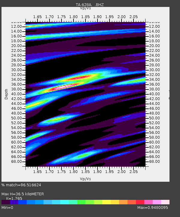
| Estimated Moho Depth: |
36.5 km |
| Estimated Crust Vp/Vs: |
1.76 |
| Assumed Crust Vp: |
6.419 km/s |
| Estimated Crust Vs: |
3.637 km/s |
| Estimated Crust Poisson's Ratio: |
0.26 |
|
| Radial Match: |
96.516624 % |
| Radial Bump: |
350 |
| Transverse Match: |
85.30335 % |
| Transverse Bump: |
400 |
| SOD ConfigId: |
2504 |
| Insert Time: |
2010-03-06 12:17:47.241 +0000 |
| GWidth: |
2.5 |
| Max Bumps: |
400 |
| Tol: |
0.001 |
|
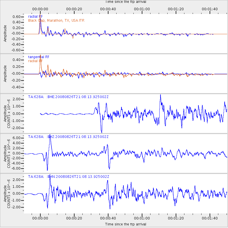
Signal To Noise
| Channel | StoN | STA | LTA |
| TA:628A: :BHZ:20080826T21:08:13.925002Z | 27.801405 | 2.144355E-6 | 7.7131176E-8 |
| TA:628A: :BHN:20080826T21:08:13.925002Z | 17.909771 | 7.38812E-7 | 4.1251894E-8 |
| TA:628A: :BHE:20080826T21:08:13.925002Z | 12.182562 | 6.28793E-7 | 5.1614183E-8 |
| Arrivals |
| Ps | 4.6 SECOND |
| PpPs | 15 SECOND |
| PsPs/PpSs | 19 SECOND |


