You are here: Home > Network List > TA - USArray Transportable Network (new EarthScope stations) Stations List
> Station 628A Black Gap, Marathon, TX, USA > Earthquake Result Viewer
628A Black Gap, Marathon, TX, USA - Earthquake Result Viewer
| Earthquake location: |
East Of Kuril Islands |
| Earthquake latitude/longitude: |
46.9/155.2 |
| Earthquake time(UTC): |
2009/01/15 (015) 17:49:39 GMT |
| Earthquake Depth: |
36 km |
| Earthquake Magnitude: |
6.9 MB, 7.5 MS, 7.4 MW, 7.4 MW |
| Earthquake Catalog/Contributor: |
WHDF/NEIC |
|
| Network: |
TA USArray Transportable Network (new EarthScope stations) |
| Station: |
628A Black Gap, Marathon, TX, USA |
| Lat/Lon: |
29.49 N/102.89 W |
| Elevation: |
655 m |
|
| Distance: |
76.6 deg |
| Az: |
61.275 deg |
| Baz: |
316.351 deg |
| Ray Param: |
0.05085078 |
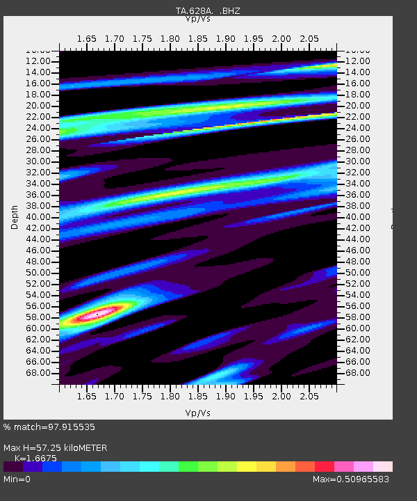
| Estimated Moho Depth: |
57.25 km |
| Estimated Crust Vp/Vs: |
1.67 |
| Assumed Crust Vp: |
6.419 km/s |
| Estimated Crust Vs: |
3.85 km/s |
| Estimated Crust Poisson's Ratio: |
0.22 |
|
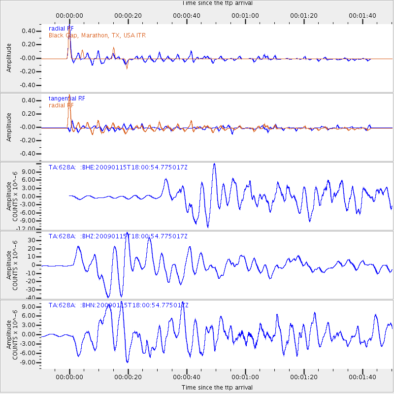
| Radial Match: |
97.915535 % |
| Radial Bump: |
353 |
| Transverse Match: |
94.398994 % |
| Transverse Bump: |
400 |
| SOD ConfigId: |
2834 |
| Insert Time: |
2010-03-06 12:18:00.421 +0000 |
| GWidth: |
2.5 |
| Max Bumps: |
400 |
| Tol: |
0.001 |
|
Signal To Noise
| Channel | StoN | STA | LTA |
| TA:628A: :BHZ:20090115T18:00:54.775017Z | 29.576977 | 1.1848113E-5 | 4.0058566E-7 |
| TA:628A: :BHN:20090115T18:00:54.775017Z | 10.802304 | 3.4195173E-6 | 3.1655443E-7 |
| TA:628A: :BHE:20090115T18:00:54.775017Z | 7.9995046 | 3.195458E-6 | 3.9945698E-7 |
| Arrivals |
| Ps | 6.2 SECOND |
| PpPs | 23 SECOND |
| PsPs/PpSs | 29 SECOND |


