You are here: Home > Network List > TA - USArray Transportable Network (new EarthScope stations) Stations List
> Station B18K Kokolik River, AK, USA > Earthquake Result Viewer
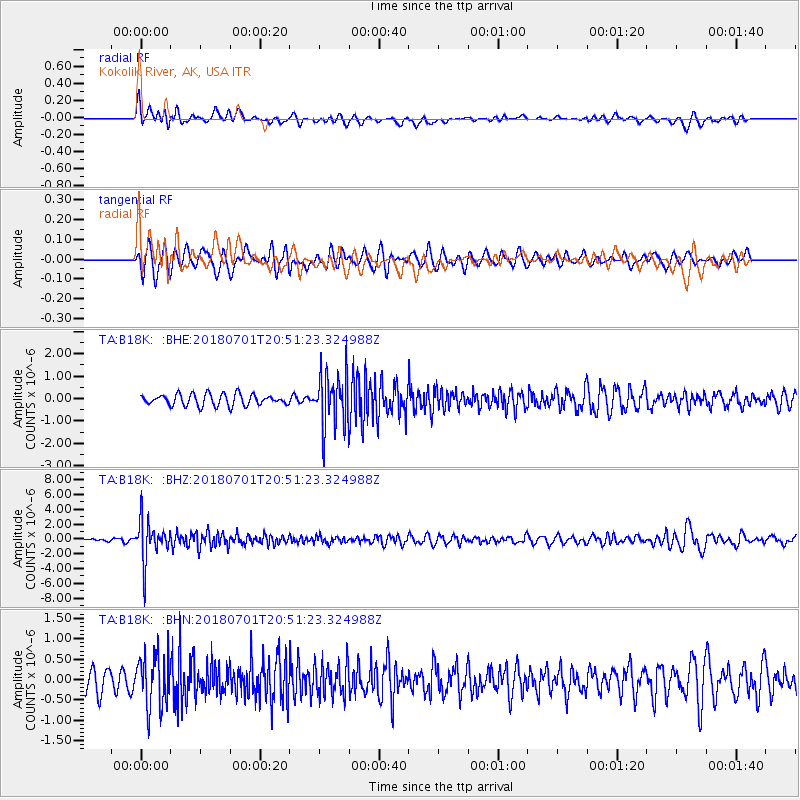
B18K Kokolik River, AK, USA - Earthquake Result Viewer
*The percent match for this event was below the threshold and hence no stack was calculated.
| Earthquake location: |
Sea Of Okhotsk |
| Earthquake latitude/longitude: |
46.9/145.0 |
| Earthquake time(UTC): |
2018/07/01 (182) 20:45:42 GMT |
| Earthquake Depth: |
388 km |
| Earthquake Magnitude: |
5.6 Mww |
| Earthquake Catalog/Contributor: |
NEIC PDE/us |
|
| Network: |
TA USArray Transportable Network (new EarthScope stations) |
| Station: |
B18K Kokolik River, AK, USA |
| Lat/Lon: |
69.36 N/161.80 W |
| Elevation: |
222 m |
|
| Distance: |
34.3 deg |
| Az: |
30.279 deg |
| Baz: |
257.098 deg |
| Ray Param: |
$rayparam |
*The percent match for this event was below the threshold and hence was not used in the summary stack. |
|
| Radial Match: |
68.11743 % |
| Radial Bump: |
400 |
| Transverse Match: |
68.801765 % |
| Transverse Bump: |
400 |
| SOD ConfigId: |
13570011 |
| Insert Time: |
2019-04-30 12:11:50.258 +0000 |
| GWidth: |
2.5 |
| Max Bumps: |
400 |
| Tol: |
0.001 |
|
Signal To Noise
| Channel | StoN | STA | LTA |
| TA:B18K: :BHZ:20180701T20:51:23.324988Z | 6.710483 | 2.7553933E-6 | 4.1061028E-7 |
| TA:B18K: :BHN:20180701T20:51:23.324988Z | 2.6403384 | 6.4245285E-7 | 2.4332215E-7 |
| TA:B18K: :BHE:20180701T20:51:23.324988Z | 4.8469276 | 1.2371441E-6 | 2.5524298E-7 |
| Arrivals |
| Ps | |
| PpPs | |
| PsPs/PpSs | |


