You are here: Home > Network List > TA - USArray Transportable Network (new EarthScope stations) Stations List
> Station D20K Etivluk River, AK, USA > Earthquake Result Viewer
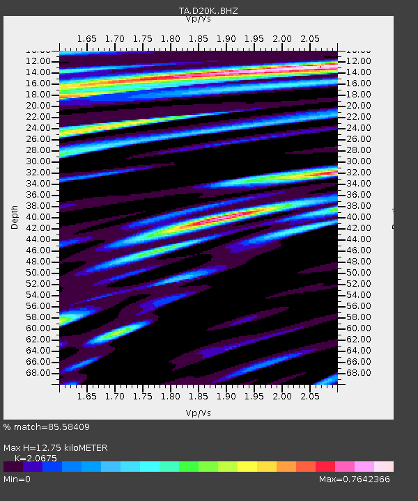
D20K Etivluk River, AK, USA - Earthquake Result Viewer
| Earthquake location: |
Sea Of Okhotsk |
| Earthquake latitude/longitude: |
46.9/145.0 |
| Earthquake time(UTC): |
2018/07/01 (182) 20:45:42 GMT |
| Earthquake Depth: |
388 km |
| Earthquake Magnitude: |
5.6 Mww |
| Earthquake Catalog/Contributor: |
NEIC PDE/us |
|
| Network: |
TA USArray Transportable Network (new EarthScope stations) |
| Station: |
D20K Etivluk River, AK, USA |
| Lat/Lon: |
68.71 N/156.61 W |
| Elevation: |
577 m |
|
| Distance: |
36.0 deg |
| Az: |
31.95 deg |
| Baz: |
263.306 deg |
| Ray Param: |
0.075262256 |
| Estimated Moho Depth: |
12.75 km |
| Estimated Crust Vp/Vs: |
2.07 |
| Assumed Crust Vp: |
6.221 km/s |
| Estimated Crust Vs: |
3.009 km/s |
| Estimated Crust Poisson's Ratio: |
0.35 |
|
| Radial Match: |
85.58409 % |
| Radial Bump: |
400 |
| Transverse Match: |
80.457726 % |
| Transverse Bump: |
400 |
| SOD ConfigId: |
13570011 |
| Insert Time: |
2019-04-30 12:12:04.532 +0000 |
| GWidth: |
2.5 |
| Max Bumps: |
400 |
| Tol: |
0.001 |
|

Signal To Noise
| Channel | StoN | STA | LTA |
| TA:D20K: :BHZ:20180701T20:51:37.875006Z | 47.183975 | 3.4623072E-6 | 7.3378885E-8 |
| TA:D20K: :BHN:20180701T20:51:37.875006Z | 15.965652 | 1.0624071E-6 | 6.654329E-8 |
| TA:D20K: :BHE:20180701T20:51:37.875006Z | 34.635376 | 1.7726305E-6 | 5.117977E-8 |
| Arrivals |
| Ps | 2.3 SECOND |
| PpPs | 5.9 SECOND |
| PsPs/PpSs | 8.3 SECOND |


