You are here: Home > Network List > TA - USArray Transportable Network (new EarthScope stations) Stations List
> Station 628A Black Gap, Marathon, TX, USA > Earthquake Result Viewer
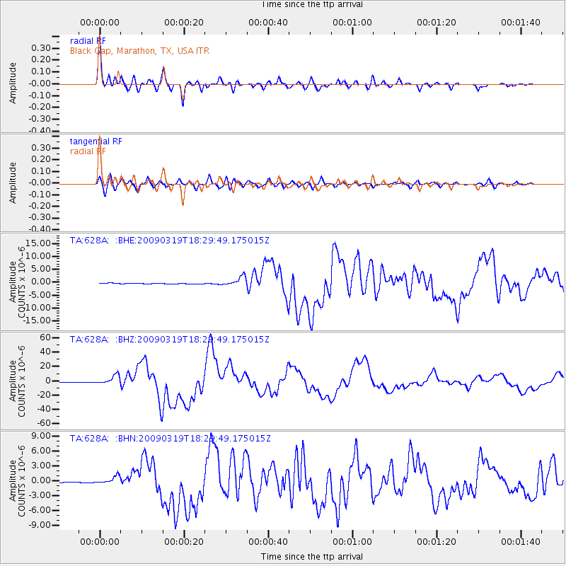
628A Black Gap, Marathon, TX, USA - Earthquake Result Viewer

| Earthquake location: |
Tonga Islands Region |
| Earthquake latitude/longitude: |
-23.0/-174.7 |
| Earthquake time(UTC): |
2009/03/19 (078) 18:17:40 GMT |
| Earthquake Depth: |
34 km |
| Earthquake Magnitude: |
7.0 MB, 7.6 MS, 7.6 MW, 7.6 MW |
| Earthquake Catalog/Contributor: |
WHDF/NEIC |
|
| Network: |
TA USArray Transportable Network (new EarthScope stations) |
| Station: |
628A Black Gap, Marathon, TX, USA |
| Lat/Lon: |
29.49 N/102.89 W |
| Elevation: |
655 m |
|
| Distance: |
86.5 deg |
| Az: |
56.063 deg |
| Baz: |
241.225 deg |
| Ray Param: |
0.04394439 |
| Estimated Moho Depth: |
34.5 km |
| Estimated Crust Vp/Vs: |
1.87 |
| Assumed Crust Vp: |
6.419 km/s |
| Estimated Crust Vs: |
3.433 km/s |
| Estimated Crust Poisson's Ratio: |
0.30 |
|
| Radial Match: |
98.1199 % |
| Radial Bump: |
396 |
| Transverse Match: |
90.18773 % |
| Transverse Bump: |
400 |
| SOD ConfigId: |
2658 |
| Insert Time: |
2010-03-06 12:18:42.407 +0000 |
| GWidth: |
2.5 |
| Max Bumps: |
400 |
| Tol: |
0.001 |
|
Signal To Noise
| Channel | StoN | STA | LTA |
| TA:628A: :BHZ:20090319T18:29:49.175015Z | 24.780005 | 6.545158E-6 | 2.6413062E-7 |
| TA:628A: :BHN:20090319T18:29:49.175015Z | 11.975247 | 8.235027E-7 | 6.876707E-8 |
| TA:628A: :BHE:20090319T18:29:49.175015Z | 12.172938 | 1.8403293E-6 | 1.5118202E-7 |
| Arrivals |
| Ps | 4.8 SECOND |
| PpPs | 15 SECOND |
| PsPs/PpSs | 20 SECOND |


