You are here: Home > Network List > GS - US Geological Survey Networks Stations List
> Station KAN10 Keim Farm > Earthquake Result Viewer
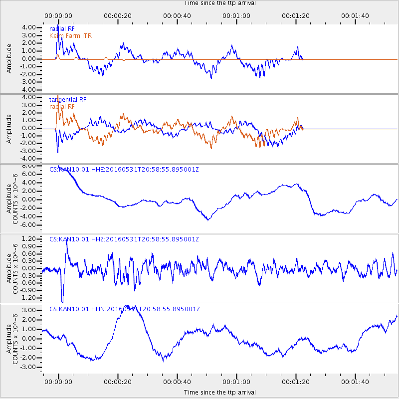
KAN10 Keim Farm - Earthquake Result Viewer
*The percent match for this event was below the threshold and hence no stack was calculated.
| Earthquake location: |
Alaska Peninsula |
| Earthquake latitude/longitude: |
55.4/-158.5 |
| Earthquake time(UTC): |
2016/05/31 (152) 20:51:22 GMT |
| Earthquake Depth: |
39 km |
| Earthquake Magnitude: |
5.7 MWW, 5.4 MI, 5.7 MWC, 5.8 MB, 5.8 MWB |
| Earthquake Catalog/Contributor: |
NEIC PDE/NEIC COMCAT |
|
| Network: |
GS US Geological Survey Networks |
| Station: |
KAN10 Keim Farm |
| Lat/Lon: |
37.12 N/98.10 W |
| Elevation: |
417 m |
|
| Distance: |
44.1 deg |
| Az: |
88.488 deg |
| Baz: |
314.542 deg |
| Ray Param: |
$rayparam |
*The percent match for this event was below the threshold and hence was not used in the summary stack. |
|
| Radial Match: |
38.00938 % |
| Radial Bump: |
293 |
| Transverse Match: |
51.21087 % |
| Transverse Bump: |
367 |
| SOD ConfigId: |
1475611 |
| Insert Time: |
2016-06-14 20:54:15.509 +0000 |
| GWidth: |
2.5 |
| Max Bumps: |
400 |
| Tol: |
0.001 |
|
Signal To Noise
| Channel | StoN | STA | LTA |
| GS:KAN10:01:HHZ:20160531T20:58:55.895001Z | 5.214944 | 6.0690877E-7 | 1.1637878E-7 |
| GS:KAN10:01:HHN:20160531T20:58:55.895001Z | 0.53682566 | 1.6607713E-6 | 3.0936885E-6 |
| GS:KAN10:01:HHE:20160531T20:58:55.895001Z | 0.84127444 | 2.4938236E-6 | 2.9643402E-6 |
| Arrivals |
| Ps | |
| PpPs | |
| PsPs/PpSs | |


