You are here: Home > Network List > TA - USArray Transportable Network (new EarthScope stations) Stations List
> Station G21K Allakaket, AK, USA > Earthquake Result Viewer
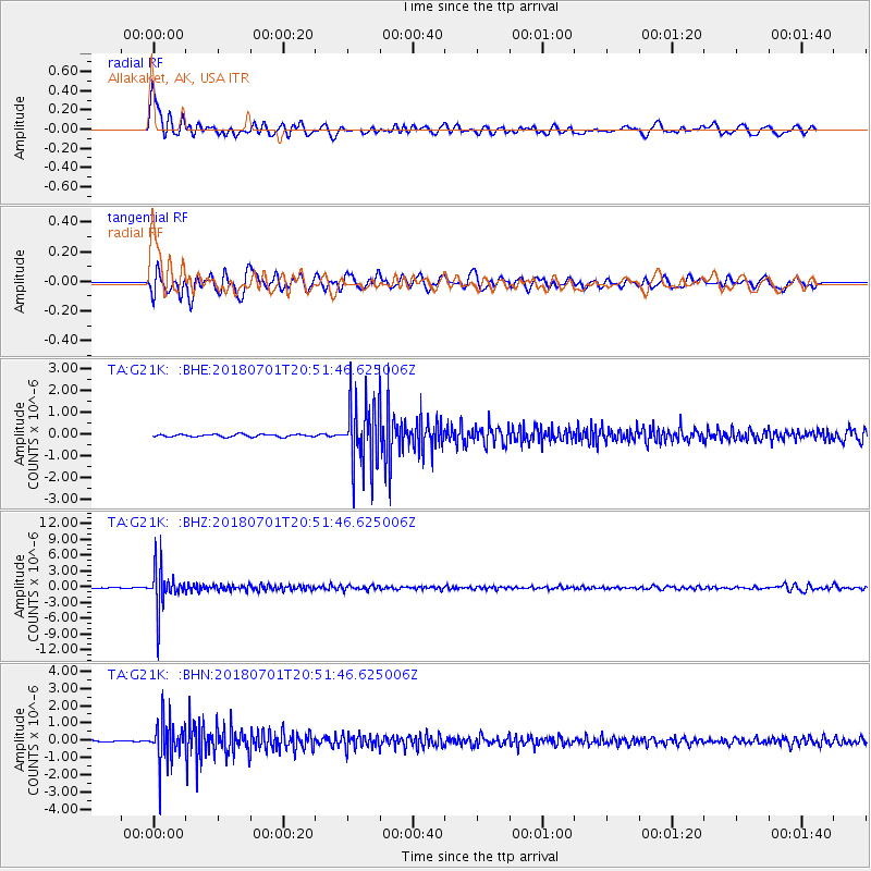
G21K Allakaket, AK, USA - Earthquake Result Viewer
*The percent match for this event was below the threshold and hence no stack was calculated.
| Earthquake location: |
Sea Of Okhotsk |
| Earthquake latitude/longitude: |
46.9/145.0 |
| Earthquake time(UTC): |
2018/07/01 (182) 20:45:42 GMT |
| Earthquake Depth: |
388 km |
| Earthquake Magnitude: |
5.6 Mww |
| Earthquake Catalog/Contributor: |
NEIC PDE/us |
|
| Network: |
TA USArray Transportable Network (new EarthScope stations) |
| Station: |
G21K Allakaket, AK, USA |
| Lat/Lon: |
66.52 N/153.51 W |
| Elevation: |
446 m |
|
| Distance: |
37.0 deg |
| Az: |
35.782 deg |
| Baz: |
269.257 deg |
| Ray Param: |
$rayparam |
*The percent match for this event was below the threshold and hence was not used in the summary stack. |
|
| Radial Match: |
77.55254 % |
| Radial Bump: |
400 |
| Transverse Match: |
82.58004 % |
| Transverse Bump: |
400 |
| SOD ConfigId: |
13570011 |
| Insert Time: |
2019-04-30 12:12:33.953 +0000 |
| GWidth: |
2.5 |
| Max Bumps: |
400 |
| Tol: |
0.001 |
|
Signal To Noise
| Channel | StoN | STA | LTA |
| TA:G21K: :BHZ:20180701T20:51:46.625006Z | 76.13916 | 3.9179804E-6 | 5.145815E-8 |
| TA:G21K: :BHN:20180701T20:51:46.625006Z | 35.427242 | 1.237305E-6 | 3.4925243E-8 |
| TA:G21K: :BHE:20180701T20:51:46.625006Z | 27.371447 | 1.5685938E-6 | 5.730767E-8 |
| Arrivals |
| Ps | |
| PpPs | |
| PsPs/PpSs | |


