You are here: Home > Network List > TA - USArray Transportable Network (new EarthScope stations) Stations List
> Station G22K Bettles, AK, USA > Earthquake Result Viewer
G22K Bettles, AK, USA - Earthquake Result Viewer

| Earthquake location: |
Sea Of Okhotsk |
| Earthquake latitude/longitude: |
46.9/145.0 |
| Earthquake time(UTC): |
2018/07/01 (182) 20:45:42 GMT |
| Earthquake Depth: |
388 km |
| Earthquake Magnitude: |
5.6 Mww |
| Earthquake Catalog/Contributor: |
NEIC PDE/us |
|
| Network: |
TA USArray Transportable Network (new EarthScope stations) |
| Station: |
G22K Bettles, AK, USA |
| Lat/Lon: |
66.92 N/151.51 W |
| Elevation: |
205 m |
|
| Distance: |
37.8 deg |
| Az: |
35.114 deg |
| Baz: |
270.56 deg |
| Ray Param: |
0.07423153 |
| Estimated Moho Depth: |
37.25 km |
| Estimated Crust Vp/Vs: |
1.77 |
| Assumed Crust Vp: |
6.577 km/s |
| Estimated Crust Vs: |
3.71 km/s |
| Estimated Crust Poisson's Ratio: |
0.27 |
|
| Radial Match: |
83.105225 % |
| Radial Bump: |
400 |
| Transverse Match: |
79.902664 % |
| Transverse Bump: |
400 |
| SOD ConfigId: |
13570011 |
| Insert Time: |
2019-04-30 12:12:34.425 +0000 |
| GWidth: |
2.5 |
| Max Bumps: |
400 |
| Tol: |
0.001 |
|
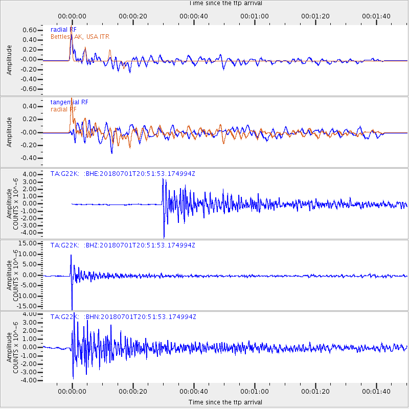
Signal To Noise
| Channel | StoN | STA | LTA |
| TA:G22K: :BHZ:20180701T20:51:53.174994Z | 62.1537 | 3.793115E-6 | 6.102798E-8 |
| TA:G22K: :BHN:20180701T20:51:53.174994Z | 25.200642 | 1.5633626E-6 | 6.203662E-8 |
| TA:G22K: :BHE:20180701T20:51:53.174994Z | 43.12691 | 1.6431854E-6 | 3.810116E-8 |
| Arrivals |
| Ps | 4.7 SECOND |
| PpPs | 15 SECOND |
| PsPs/PpSs | 19 SECOND |


