You are here: Home > Network List > TA - USArray Transportable Network (new EarthScope stations) Stations List
> Station 628A Black Gap, Marathon, TX, USA > Earthquake Result Viewer
628A Black Gap, Marathon, TX, USA - Earthquake Result Viewer
| Earthquake location: |
Southern Peru |
| Earthquake latitude/longitude: |
-15.0/-70.4 |
| Earthquake time(UTC): |
2009/07/12 (193) 06:12:47 GMT |
| Earthquake Depth: |
199 km |
| Earthquake Magnitude: |
5.7 MB, 6.1 MW, 6.1 MW |
| Earthquake Catalog/Contributor: |
WHDF/NEIC |
|
| Network: |
TA USArray Transportable Network (new EarthScope stations) |
| Station: |
628A Black Gap, Marathon, TX, USA |
| Lat/Lon: |
29.49 N/102.89 W |
| Elevation: |
655 m |
|
| Distance: |
54.2 deg |
| Az: |
324.794 deg |
| Baz: |
140.292 deg |
| Ray Param: |
0.064899206 |
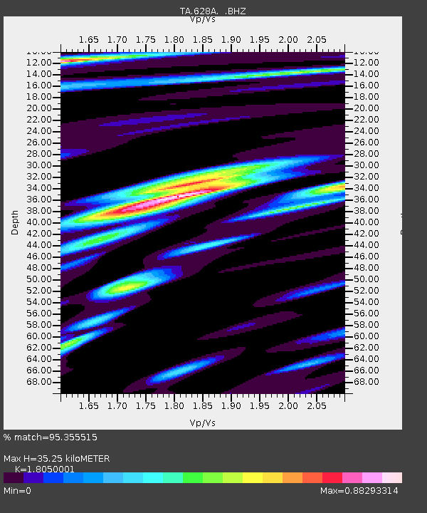
| Estimated Moho Depth: |
35.25 km |
| Estimated Crust Vp/Vs: |
1.81 |
| Assumed Crust Vp: |
6.419 km/s |
| Estimated Crust Vs: |
3.556 km/s |
| Estimated Crust Poisson's Ratio: |
0.28 |
|
| Radial Match: |
95.355515 % |
| Radial Bump: |
400 |
| Transverse Match: |
83.99119 % |
| Transverse Bump: |
400 |
| SOD ConfigId: |
2648 |
| Insert Time: |
2010-03-06 12:18:47.204 +0000 |
| GWidth: |
2.5 |
| Max Bumps: |
400 |
| Tol: |
0.001 |
|
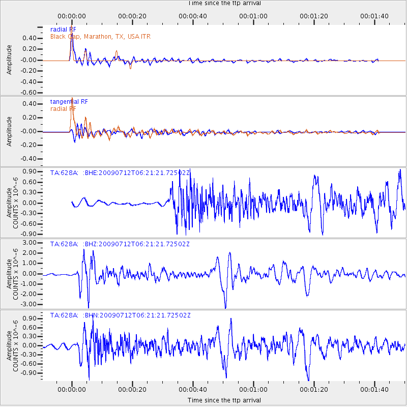
Signal To Noise
| Channel | StoN | STA | LTA |
| TA:628A: :BHZ:20090712T06:21:21.72502Z | 12.081972 | 9.802895E-7 | 8.113655E-8 |
| TA:628A: :BHN:20090712T06:21:21.72502Z | 8.019824 | 3.2278578E-7 | 4.0248487E-8 |
| TA:628A: :BHE:20090712T06:21:21.72502Z | 4.983121 | 2.7166524E-7 | 5.4517088E-8 |
| Arrivals |
| Ps | 4.7 SECOND |
| PpPs | 15 SECOND |
| PsPs/PpSs | 19 SECOND |


