You are here: Home > Network List > TA - USArray Transportable Network (new EarthScope stations) Stations List
> Station 628A Black Gap, Marathon, TX, USA > Earthquake Result Viewer
628A Black Gap, Marathon, TX, USA - Earthquake Result Viewer
| Earthquake location: |
Kuril Islands |
| Earthquake latitude/longitude: |
46.0/151.5 |
| Earthquake time(UTC): |
2009/04/07 (097) 04:23:33 GMT |
| Earthquake Depth: |
31 km |
| Earthquake Magnitude: |
6.5 MB, 6.8 MS, 6.9 MW, 6.9 MW |
| Earthquake Catalog/Contributor: |
WHDF/NEIC |
|
| Network: |
TA USArray Transportable Network (new EarthScope stations) |
| Station: |
628A Black Gap, Marathon, TX, USA |
| Lat/Lon: |
29.49 N/102.89 W |
| Elevation: |
655 m |
|
| Distance: |
79.1 deg |
| Az: |
58.787 deg |
| Baz: |
316.909 deg |
| Ray Param: |
0.04912698 |
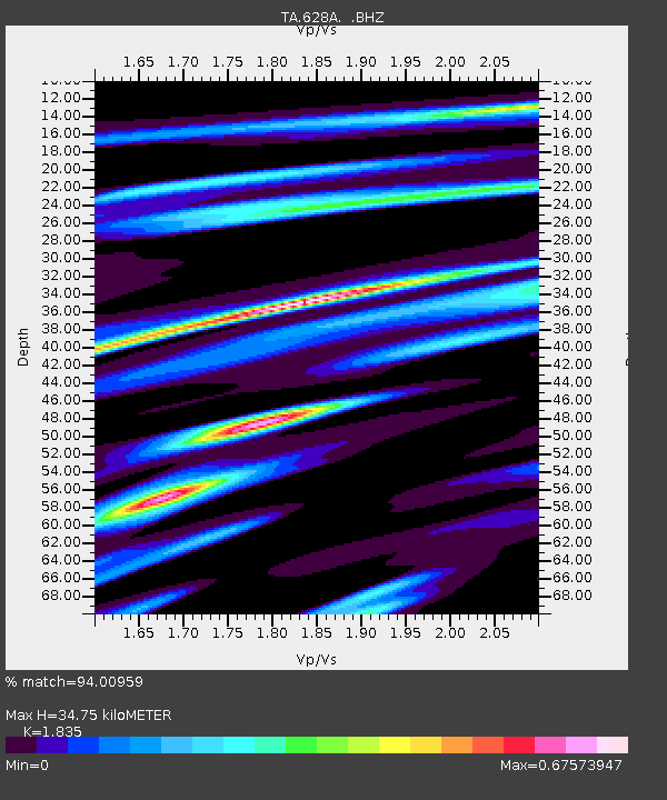
| Estimated Moho Depth: |
34.75 km |
| Estimated Crust Vp/Vs: |
1.84 |
| Assumed Crust Vp: |
6.419 km/s |
| Estimated Crust Vs: |
3.498 km/s |
| Estimated Crust Poisson's Ratio: |
0.29 |
|
| Radial Match: |
94.00959 % |
| Radial Bump: |
400 |
| Transverse Match: |
85.62321 % |
| Transverse Bump: |
400 |
| SOD ConfigId: |
2658 |
| Insert Time: |
2010-03-06 12:18:50.632 +0000 |
| GWidth: |
2.5 |
| Max Bumps: |
400 |
| Tol: |
0.001 |
|
Signal To Noise
| Channel | StoN | STA | LTA |
| TA:628A: :BHZ:20090407T04:35:03.600012Z | 24.617355 | 3.7554744E-6 | 1.5255394E-7 |
| TA:628A: :BHN:20090407T04:35:03.600012Z | 9.183884 | 1.1597649E-6 | 1.2628261E-7 |
| TA:628A: :BHE:20090407T04:35:03.600012Z | 6.4038825 | 1.1777109E-6 | 1.8390577E-7 |
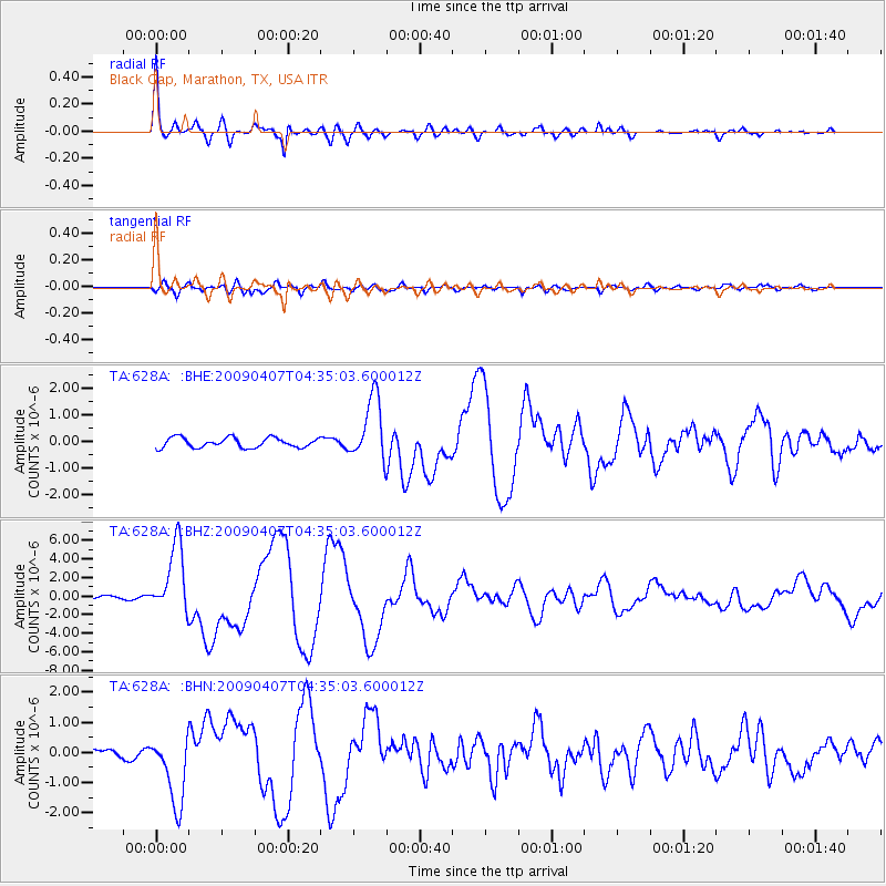
| Arrivals |
| Ps | 4.6 SECOND |
| PpPs | 15 SECOND |
| PsPs/PpSs | 20 SECOND |


