You are here: Home > Network List > TA - USArray Transportable Network (new EarthScope stations) Stations List
> Station J17K VABM Dome, AK, USA > Earthquake Result Viewer
J17K VABM Dome, AK, USA - Earthquake Result Viewer
| Earthquake location: |
Sea Of Okhotsk |
| Earthquake latitude/longitude: |
46.9/145.0 |
| Earthquake time(UTC): |
2018/07/01 (182) 20:45:42 GMT |
| Earthquake Depth: |
388 km |
| Earthquake Magnitude: |
5.6 Mww |
| Earthquake Catalog/Contributor: |
NEIC PDE/us |
|
| Network: |
TA USArray Transportable Network (new EarthScope stations) |
| Station: |
J17K VABM Dome, AK, USA |
| Lat/Lon: |
63.40 N/159.08 W |
| Elevation: |
323 m |
|
| Distance: |
34.6 deg |
| Az: |
41.049 deg |
| Baz: |
268.486 deg |
| Ray Param: |
0.076035425 |
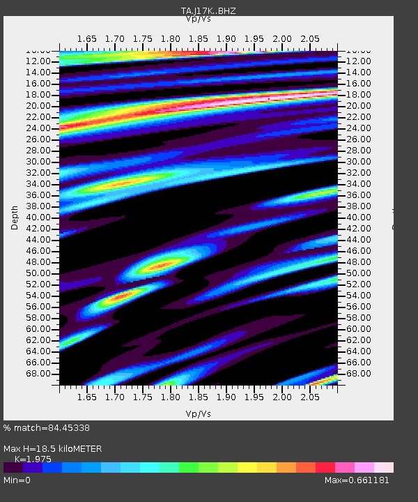
| Estimated Moho Depth: |
18.5 km |
| Estimated Crust Vp/Vs: |
1.98 |
| Assumed Crust Vp: |
6.276 km/s |
| Estimated Crust Vs: |
3.178 km/s |
| Estimated Crust Poisson's Ratio: |
0.33 |
|
| Radial Match: |
84.45338 % |
| Radial Bump: |
393 |
| Transverse Match: |
75.49638 % |
| Transverse Bump: |
400 |
| SOD ConfigId: |
13570011 |
| Insert Time: |
2019-04-30 12:12:58.942 +0000 |
| GWidth: |
2.5 |
| Max Bumps: |
400 |
| Tol: |
0.001 |
|

Signal To Noise
| Channel | StoN | STA | LTA |
| TA:J17K: :BHZ:20180701T20:51:26.275Z | 26.035112 | 1.8865211E-6 | 7.246065E-8 |
| TA:J17K: :BHN:20180701T20:51:26.275Z | 9.445859 | 5.8356903E-7 | 6.178041E-8 |
| TA:J17K: :BHE:20180701T20:51:26.275Z | 20.455154 | 9.837322E-7 | 4.8092144E-8 |
| Arrivals |
| Ps | 3.1 SECOND |
| PpPs | 8.2 SECOND |
| PsPs/PpSs | 11 SECOND |


