You are here: Home > Network List > TA - USArray Transportable Network (new EarthScope stations) Stations List
> Station MDND Maddock, ND, USA > Earthquake Result Viewer
MDND Maddock, ND, USA - Earthquake Result Viewer
*The percent match for this event was below the threshold and hence no stack was calculated.
| Earthquake location: |
Sea Of Okhotsk |
| Earthquake latitude/longitude: |
46.9/145.0 |
| Earthquake time(UTC): |
2018/07/01 (182) 20:45:42 GMT |
| Earthquake Depth: |
388 km |
| Earthquake Magnitude: |
5.6 Mww |
| Earthquake Catalog/Contributor: |
NEIC PDE/us |
|
| Network: |
TA USArray Transportable Network (new EarthScope stations) |
| Station: |
MDND Maddock, ND, USA |
| Lat/Lon: |
47.85 N/99.60 W |
| Elevation: |
479 m |
|
| Distance: |
70.1 deg |
| Az: |
40.321 deg |
| Baz: |
318.824 deg |
| Ray Param: |
$rayparam |
*The percent match for this event was below the threshold and hence was not used in the summary stack. |
|
| Radial Match: |
54.35159 % |
| Radial Bump: |
400 |
| Transverse Match: |
47.493847 % |
| Transverse Bump: |
400 |
| SOD ConfigId: |
13570011 |
| Insert Time: |
2019-04-30 12:13:38.132 +0000 |
| GWidth: |
2.5 |
| Max Bumps: |
400 |
| Tol: |
0.001 |
|
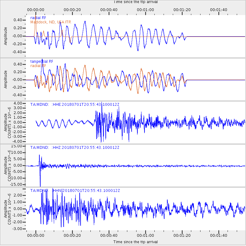
Signal To Noise
| Channel | StoN | STA | LTA |
| TA:MDND: :HHZ:20180701T20:55:43.100012Z | 27.382175 | 3.7757984E-6 | 1.3789256E-7 |
| TA:MDND: :HHN:20180701T20:55:43.100012Z | 1.981702 | 8.9207043E-7 | 4.501537E-7 |
| TA:MDND: :HHE:20180701T20:55:43.100012Z | 2.4075582 | 1.1752405E-6 | 4.8814627E-7 |
| Arrivals |
| Ps | |
| PpPs | |
| PsPs/PpSs | |


