You are here: Home > Network List > TA - USArray Transportable Network (new EarthScope stations) Stations List
> Station T25A Trinidad, CO, USA > Earthquake Result Viewer
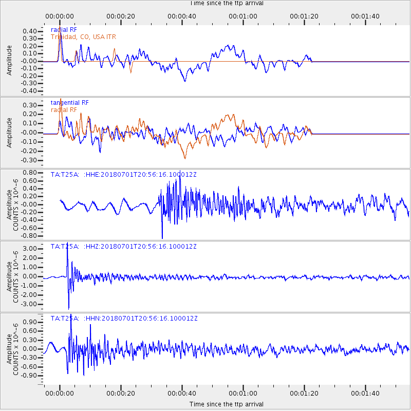
T25A Trinidad, CO, USA - Earthquake Result Viewer
*The percent match for this event was below the threshold and hence no stack was calculated.
| Earthquake location: |
Sea Of Okhotsk |
| Earthquake latitude/longitude: |
46.9/145.0 |
| Earthquake time(UTC): |
2018/07/01 (182) 20:45:42 GMT |
| Earthquake Depth: |
388 km |
| Earthquake Magnitude: |
5.6 Mww |
| Earthquake Catalog/Contributor: |
NEIC PDE/us |
|
| Network: |
TA USArray Transportable Network (new EarthScope stations) |
| Station: |
T25A Trinidad, CO, USA |
| Lat/Lon: |
37.14 N/104.41 W |
| Elevation: |
2017 m |
|
| Distance: |
75.8 deg |
| Az: |
50.5 deg |
| Baz: |
318.566 deg |
| Ray Param: |
$rayparam |
*The percent match for this event was below the threshold and hence was not used in the summary stack. |
|
| Radial Match: |
44.42166 % |
| Radial Bump: |
400 |
| Transverse Match: |
60.235744 % |
| Transverse Bump: |
400 |
| SOD ConfigId: |
13570011 |
| Insert Time: |
2019-04-30 12:14:24.953 +0000 |
| GWidth: |
2.5 |
| Max Bumps: |
400 |
| Tol: |
0.001 |
|
Signal To Noise
| Channel | StoN | STA | LTA |
| TA:T25A: :HHZ:20180701T20:56:16.100012Z | 18.192919 | 1.1428774E-6 | 6.28199E-8 |
| TA:T25A: :HHN:20180701T20:56:16.100012Z | 5.000548 | 3.492629E-7 | 6.984492E-8 |
| TA:T25A: :HHE:20180701T20:56:16.100012Z | 2.3745592 | 2.0874981E-7 | 8.7910976E-8 |
| Arrivals |
| Ps | |
| PpPs | |
| PsPs/PpSs | |


